Krokos
| Krokos Κρόκος | |
|---|---|
 Krokos | |
| Coordinates: 40°16′N 21°49′E / 40.267°N 21.817°ECoordinates: 40°16′N 21°49′E / 40.267°N 21.817°E | |
| Country | Greece |
| Administrative region | West Macedonia |
| Regional unit | Kozani |
| Municipality | Kozani |
| Municipal unit | Elimeia |
| Community[1] | |
| • Population | 2,977 (2011) |
| Time zone | UTC+2 (EET) |
| • Summer (DST) | UTC+3 (EEST) |
Krokos (Greek: Κρόκος, before 1927: Γκόβλιτσα - Govlitsa,[2][3][4] Bulgarian: Гоблица and Macedonian: Гоблица[5] today sometimes still called with the name Gomblitsa or Greek: Γκόμπλιτσα) is a small Greek town (κωμόπολη / komopoli), only 5 km south of the city of Kozani in the geographical region of Macedonia, in Greece. It was the seat of the municipality of Elimeia. Its population was 2,977 at the 2011 census.[1]
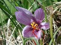
Krokos Kozanis (Saffron)
Krokos is renowned in Greece and abroad for the production of the Greek Macedonian Saffron, which is one of the world's most intense and valuable varieties. Although the ancient Minoans were known to cultivate saffron during Late Bronze Age Crete, the cultivation of the plant disappeared from Greece until about 300 years ago, when Greek Macedonian traders brought the plant from Austria to the region of Kozani. The town of Krokos is the base of the Cooperative of Saffron Producers of Kozani, a cooperative that counts 2000 members spread between 40 small villages. Annual production, depending on weather conditions, ranges from 6 to 12 tons of pure red saffron each year. Much of this production is certified organic. All of it is Protected Designation of Origin (PDO); no other region of Greece can produce Greek Red Saffron. It is also extremely high-quality: Greek Red Saffron, as provided by the Kozani Cooperative, has a guaranteed coloring strength of 230.
Climate
| Climate data for Kozani | |||||||||||||
|---|---|---|---|---|---|---|---|---|---|---|---|---|---|
| Month | Jan | Feb | Mar | Apr | May | Jun | Jul | Aug | Sep | Oct | Nov | Dec | Year |
| Average high °C (°F) | 6 (43) |
9 (48) |
12 (53) |
17 (63) |
21 (69) |
26 (78) |
29 (85) |
28 (82) |
25 (77) |
19 (66) |
13 (56) |
6 (43) |
18 (64) |
| Average low °C (°F) | −2 (29) |
0 (32) |
1 (34) |
7 (44) |
10 (50) |
14 (57) |
17 (62) |
16 (61) |
13 (56) |
8 (47) |
4 (40) |
1 (33) |
7 (45) |
| Average precipitation mm (inches) | 53 (2.1) |
30 (1.2) |
36 (1.4) |
48 (1.9) |
64 (2.5) |
64 (2.5) |
38 (1.5) |
28 (1.1) |
28 (1.1) |
81 (3.2) |
86 (3.4) |
135 (5.3) |
688 (27.1) |
| Source: Weatherbase [6] | |||||||||||||
External links
References
- 1 2 "Απογραφή Πληθυσμού - Κατοικιών 2011. ΜΟΝΙΜΟΣ Πληθυσμός" (in Greek). Hellenic Statistical Authority.
- ↑ Name changes of settlements in Greece
- ↑ mikrovalto.gr
- ↑ lithoksou.net
- ↑ https://macedon.wordpress.com/2007/07/23/macedonian-village-names/
- ↑ "Weatherbase: Historical Weather for Kozani, Greece". Weatherbase. 2011. Retrieved on November 24, 2011.