Elimeia
| Elimeia Ελιμεία | |
|---|---|
 Elimeia Location within the regional unit 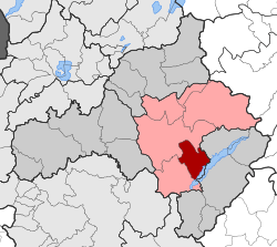 | |
| Coordinates: 40°14′N 21°50′E / 40.233°N 21.833°ECoordinates: 40°14′N 21°50′E / 40.233°N 21.833°E | |
| Country | Greece |
| Administrative region | West Macedonia |
| Regional unit | Kozani |
| Municipality | Kozani |
| • Municipal unit | 99.166 km2 (38.288 sq mi) |
| Elevation | 496 m (1,627 ft) |
| Population (2011)[1] | |
| • Municipal unit | 5,910 |
| • Municipal unit density | 60/km2 (150/sq mi) |
| Time zone | UTC+2 (EET) |
| • Summer (DST) | UTC+3 (EEST) |
| Vehicle registration | KZ |
Elimeia (Greek: Ελιμεία) is a former municipality in Kozani regional unit, West Macedonia, Greece. Since the 2011 local government reform it is part of the municipality Kozani, of which it is a municipal unit.[2] The municipal unit has an area of 99.166 km2.[3] The population is 5,910 (2011). The seat of the municipality was in Krokos. In the referendum that took place in the spring of 2006, 55% of the inhabitants voted for the union of their municipality with Kozani.
References
- ↑ "Απογραφή Πληθυσμού - Κατοικιών 2011. ΜΟΝΙΜΟΣ Πληθυσμός" (in Greek). Hellenic Statistical Authority.
- ↑ Kallikratis law Greece Ministry of Interior (in Greek)
- ↑ "Population & housing census 2001 (incl. area and average elevation)" (PDF) (in Greek). National Statistical Service of Greece. Archived from the original (PDF) on 2015-09-21.
This article is issued from
Wikipedia.
The text is licensed under Creative Commons - Attribution - Sharealike.
Additional terms may apply for the media files.