Krkavče
| Krkavče | |
|---|---|
 | |
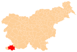
 Krkavče Location in Slovenia | |
| Coordinates: 45°27′50.35″N 13°41′34.09″E / 45.4639861°N 13.6928028°ECoordinates: 45°27′50.35″N 13°41′34.09″E / 45.4639861°N 13.6928028°E | |
| Country |
|
| Traditional region | Littoral |
| Statistical region | Coastal–Karst |
| Municipality | Koper |
| Area | |
| • Total | 6.45 km2 (2.49 sq mi) |
| Elevation | 185.3 m (607.9 ft) |
| Population (2002) | |
| • Total | 254 |
| [1] | |
Krkavče (pronounced [ˈkəɾkau̯tʃɛ]; Italian: Carcauzze[2] or Carcase[3]) is a village in the City Municipality of Koper in the Littoral region of Slovenia close to the border with Croatia.[4] It includes the hamlets of Abrabi, Draga, Girič, Glavini, Hrib, Mačkujek, Pršuti, Rov, Škrljevec, Solni, Sveti Maver, and Žvabi.[5]
Church
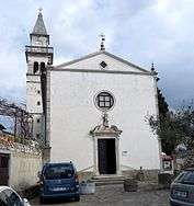
West facade
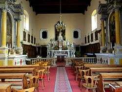
Church interior
Archangel Michael's Church
The parish church in the settlement is dedicated to Saint Michael.[6] It was built on the bare stone village square in 1749.
See also
References
- ↑ Statistical Office of the Republic of Slovenia Archived November 18, 2008, at the Wayback Machine.
- ↑ Spezialortsrepertorium der österreichischen Länder. Bearbeiten auf Grund der Ergebnisse der Volkszälung vom 31. Dezember 1910, vol. 7: Österreichisch-Illyrisches Küstenland. 1918. Vienna: K. k. Hof- und Staatsdruckerei, p. 34.
- ↑ Atlante stradale d'Italia. Nord. 2004. Milan: Touring Club Italiano, map 20.
- ↑ Koper municipal site Archived March 8, 2009, at the Wayback Machine.
- ↑ Savnik, Roman, ed. 1968. Krajevni leksikon Slovenije, vol. 1. Ljubljana: Državna založba Slovenije. p. 136.
- ↑ Roman Catholic Diocese of Koper List of Churches May 2008 Archived March 6, 2009, at the Wayback Machine.
External links

- Krkavče on Geopedia
This article is issued from
Wikipedia.
The text is licensed under Creative Commons - Attribution - Sharealike.
Additional terms may apply for the media files.