Krishnarajanagara
| Krishnarajanagara Hosa Yedatore | |
|---|---|
| city | |
| Nickname(s): KRN | |
| Coordinates: 12°28′N 76°23′E / 12.46°N 76.39°ECoordinates: 12°28′N 76°23′E / 12.46°N 76.39°E | |
| Country |
|
| State | Karnataka |
| District | Mysore |
| Population (2001) | |
| • Total | 30,603 |
| Languages | |
| • Official | Kannada |
| Time zone | UTC+5:30 (IST) |
| PIN | 571 602 |
| Telephone code | 08223 |
| Vehicle registration | KA-45 |
| Website |
[<span%20class="url"> |
.jpg)
Krishnarajanagara (sometimes abbreviated to K.R. Nagara) is a town in Mysore district in the Indian state of Karnataka.
Krishnarajanagara was founded between 1925s and 1930s as a new town, when a flood by river Kaveri damaged the nearby old town called Yedatore. The town was shifted to a place 3 miles south and at a higher elevation, now called Krishnarajanagara. It was named after Krisharaja Wodeyar, the maharaja of Mysore. Krishnarajanagara is a town with broad roads. Krishnarajanagara is well connected by rail and road to places such as Mysore, Hassan and Hunsur. The famous Chunchanakatte Falls are located about 13 km from Krishnarajanagar.
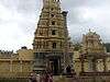
Arkeshwara Swamy temple is situated on the bank of river Kaveri and a jathra (car festival) is celebrated on Rathasaptami day.
Getting there
By road
From the state capital Bangalore, one can take the State Highway 17 which goes to Mysore and then onwards to K R Nagar. The total distance from Bangalore to K R Nagar is around 186 km.
By rail
Krishnarajanagara has a railway station with broad gauge line (the standard gauge followed by Indian Railways) which runs from Mysore to Krishnarajanagara. Mysore being an important location is well connected by rail to major cities in India and hence passengers can stop over at Mysore and take another train to reach Krishnarajanagara. Many movies has been shot in this railway station..
Old Railway station
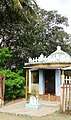
The old Railway Station of the British period is not forgotten because that area is still known by the same name. The buildings have all fallen down and only a few walls remain. There is a small temple near the old ticket counter and even the railway tracks have disappeared. The platform is still recognizable.

Location
Demographics
As of 2001 India census,[1] Krishnarajanagara had a population of 30,603. Males constitute 51% of the population and females 49%. Krishnarajanagara has an average literacy rate of 73%, higher than the national average of 59.5%: male literacy is 78%, and female literacy is 68%. In Krishnarajanagara, 11% of the population is under 6 years of age.
In this taluk among largest villages Gandhanahalli is one. K R Nagara is a well planned city in all the way. Saligrama is one of the small town that comes under K R Nagar taluk. Dornahalli is famous for jesus church located around 4 km from K R Nagara.,Saligrama is famous for Yoganarasimha Swamy temple located 25km from K.R.Nagar,yadathore Located at K.R.Nagar .Chunchana katte is famous for Sree Rama temple located 17km from K.R.Nagar.Japadha katte kshrethra Hebsoor Famous for Lord Shiva Temple Located 35km from K.R.Nagar
Image gallery
 Hospital Compound
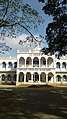 Civil Station
See also
References
- ↑ "Census of India 2001: Data from the 2001 Census, including cities, villages and towns (Provisional)". Census Commission of India. Archived from the original on 2004-06-16. Retrieved 2008-11-01.