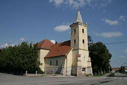
Kostolná pri Dunaji
| Kostolná pri Dunaji | |
| Egyházfa | |
| Village | |
 | |
| Country | Slovakia |
|---|---|
| Region | Bratislava |
| District | Senec |
| River | Little Danube |
| Elevation | 124 m (407 ft) |
| Coordinates | 48°11′10″N 17°26′00″E / 48.18611°N 17.43333°ECoordinates: 48°11′10″N 17°26′00″E / 48.18611°N 17.43333°E |
| Area | 8.07 km2 (3 sq mi) |
| Population | 516 (2011) |
| Density | 64/km2 (166/sq mi) |
| First mentioned | 1332 |
| Mayor | János Filkász |
| Timezone | CET (UTC+1) |
| - summer (DST) | CEST (UTC+2) |
| Postal code | 903 01 |
| Phone prefix | 421-2 |
| Car plate | SC |
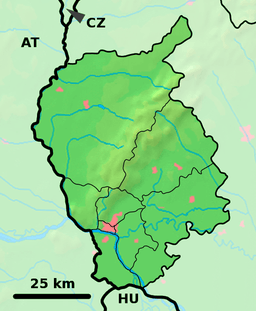 Location of Kostolná pri Dunaji in the Bratislava Region  Kostolná pri Dunaji (Slovakia) | |
| Statistics: MOŠ/MIS | |
Kostolná pri Dunaji (Hungarian: Egyházfa, meaning Church Tree) is a village and municipality in western Slovakia in Senec District in the Bratislava Region.
Geography
The municipality lies at an altitude of 128 metres and covers an area of 8.072 km².
History
In historical records the village was first mentioned in 1332. After the Austro-Hungarian army disintegrated in November 1918, Czechoslovak troops occupied the area, later acknowledged internationally by the Treaty of Trianon. Between 1938 and 1945 Kostolná pri Dunaji once more became part of Miklós Horthy's Hungary through the First Vienna Award. From 1945 until the Velvet Divorce, it was part of Czechoslovakia. Since then it has been part of Slovakia.
Population
According to the 2011 census, the municipality had 508 inhabitants. 265 of inhabitants were Hungarians, 235 Slovaks and 8 others and unspecified.[1]
See also
References
- ↑ "Archived copy" (PDF). Archived from the original (PDF) on 2012-11-14. Retrieved 2012-08-10.
Genealogical resources
The records for genealogical research are available at the state archive "Statny Archiv in Bratislava, Slovakia"
- Roman Catholic church records (births/marriages/deaths): 1711-1898 (parish A)
External links/Sources
- https://web.archive.org/web/20070513023228/http://www.statistics.sk/mosmis/eng/run.html
- Surnames of living people in Kostolna pri Dunaji