Karzok
| Karzok Korzok | |
|---|---|
| village | |
 | |
 Karzok Location in Jammu and Kashmir, India  Karzok Karzok (India) | |
| Coordinates: 32°58′05″N 78°15′50″E / 32.968125°N 78.2639885°ECoordinates: 32°58′05″N 78°15′50″E / 32.968125°N 78.2639885°E | |
| Country | India |
| State | Jammu and Kashmir |
| District | Leh |
| Tehsil | Leh |
| Elevation | 4,595 m (15,075 ft) |
| Population (2011) | |
| • Total | 1,291 |
| Time zone | UTC+5:30 (IST) |
| 2011 census code | 899 |
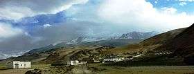
Karzok or Korzok is a village in the Leh district of Jammu and Kashmir, India.[1] It is located in the Leh tehsil, in Rupshu region, on the shore of Tso Moriri lake. It is among the highest towns in the world. Various sources give slightly different measurements of the altitude from 15,075 ft. (4,595 metres) to 14,995 feet (4,570 m) above sea level.[2] The Drukpa Buddhist Korzok Monastery is located here.
History
Karzok was on the Central Asian trade route until 1947 and was the headquarters of Rupshu Valley. One of the kings, Rupshu Goba, who lived there with his family, built nine permanent houses there.[3]
The village has several houses, and the nomadic population which establishes their tents (made of yak hair or skin) in summer, adds to the agricultural operations in the region. The tents are provided with vents at the top to let out smoke. Pashmina is the valuable product that the Changmas trade along with the salt that they extract from large salt fields in the area, such as the springs at Puga. They barter these two products for food grains and other necessities. In Karzok, in recent years, building activity is on the rise with the nomadic tribes changing their life style.[4]
Demographics
According to the 2011 census of India, Karzok has 253 households. The effective literacy rate (i.e. the literacy rate of population excluding children aged 6 and below) is 46.64%.[5]
| Total | Male | Female | |
|---|---|---|---|
| Population | 1291 | 673 | 618 |
| Children aged below 6 years | 189 | 102 | 87 |
| Scheduled caste | 4 | 2 | 2 |
| Scheduled tribe | 931 | 485 | 446 |
| Literates | 514 | 292 | 222 |
| Workers (all) | 813 | 450 | 363 |
| Main workers (total) | 315 | 225 | 90 |
| Main workers: Cultivators | 257 | 192 | 65 |
| Main workers: Agricultural labourers | 3 | 2 | 1 |
| Main workers: Household industry workers | 6 | 0 | 6 |
| Main workers: Other | 49 | 31 | 18 |
| Marginal workers (total) | 498 | 225 | 273 |
| Marginal workers: Cultivators | 224 | 117 | 107 |
| Marginal workers: Agricultural labourers | 7 | 3 | 4 |
| Marginal workers: Household industry workers | 126 | 19 | 107 |
| Marginal workers: Others | 141 | 86 | 55 |
| Non-workers | 478 | 223 | 255 |

References
| Wikimedia Commons has media related to Karzok. |
- ↑ "Blockwise Village Amenity Directory" (PDF). Ladakh Autonomous Hill Development Council. Retrieved 2015-07-23.
- ↑ List of highest cities in the world
- ↑ Jina, Prem Singh (1995). High pasturelands of Ladakh Himalaya. Korzok. Indus Publishing. p. 49. ISBN 978-81-7387-026-2. ISBN 81-7387-026-8. Retrieved 2009-11-22.
- ↑ "Tso Moriri - Tea with Changpas". The Statesman. 2004-06-16. Retrieved 2009-11-23.
- 1 2 "Leh district census". 2011 Census of India. Directorate of Census Operations. Retrieved 2015-07-23.