Korea Bay
|
Korea(n) Bay West Korea(n) Bay | |||||||
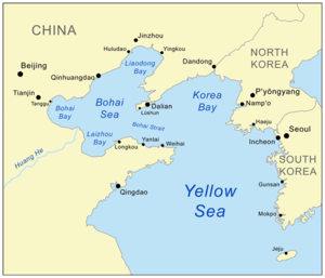 Map showing Korea Bay. | |||||||
| North Korean name | |||||||
|---|---|---|---|---|---|---|---|
| Chosŏn'gŭl | 서조선만 | ||||||
| Hancha | 西朝鮮灣 | ||||||
| |||||||
| South Korean name | |||||||
| Hangul | 서한만 | ||||||
| Hanja | 西韓灣 | ||||||
| |||||||
The Korea(n) Bay, sometimes the West Korea(n) Bay (Hangul: 서조선만 or 서한만; Hanja: 西朝鮮灣 or 西韓灣; Korean pronunciation: [sʰʌdʑosʰʌn.man] or [sʰʌhan.man]), is a northern extension of the Yellow Sea,[1] between Liaoning Province of China and North Pyongan Province of North Korea.[2]
It is separated from the Bohai by the Liaodong Peninsula, with Dalian at its southernmost point.[3][4]
The Yalu (Amnok) River, which marks the border between China and North Korea, empties into the Korea Bay between Dandong (China) and Sinŭiju (North Korea).[5][6]
See also
References
- ↑ Merriam-Webster's Geographical Dictionary, Third Edition. Springfield, Mass.: Merriam-Webster. 1998. p. 605. ISBN 0-87779-546-0.
- ↑ Merriam-Webster's Geographical Dictionary, Third Edition. Springfield, Mass.: Merriam-Webster. 1998. p. 606. ISBN 0-87779-546-0.
- ↑ Merriam-Webster's Geographical Dictionary, Third Edition. Springfield, Mass.: Merriam-Webster. 1998. p. 647. ISBN 0-87779-546-0.
- ↑ Merriam-Webster's Geographical Dictionary, Third Edition. Springfield, Mass.: Merriam-Webster. 1998. p. 300. ISBN 0-87779-546-0.
- ↑ Merriam-Webster's Geographical Dictionary, Third Edition. Springfield, Mass.: Merriam-Webster. 1998. p. 1321. ISBN 0-87779-546-0.
- ↑ Merriam-Webster's Geographical Dictionary, Third Edition. Springfield, Mass.: Merriam-Webster. 1998. p. 1092. ISBN 0-87779-546-0.
External links

This article is issued from
Wikipedia.
The text is licensed under Creative Commons - Attribution - Sharealike.
Additional terms may apply for the media files.