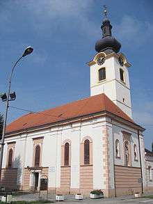
Koprivnica
| Koprivnica | ||
|---|---|---|
| City | ||
|
City of Koprivnica Grad Koprivnica | ||
 Koprivnica Main Square | ||
| ||
 Koprivnica Location of Koprivnica in Croatia | ||
| Coordinates: 46°09′46″N 16°49′42″E / 46.16278°N 16.82833°E | ||
| Country | Croatia | |
| County | Koprivnica-Križevci | |
| Government | ||
| • Mayor | Mišel Jakšić (SDP) | |
| • City Council |
21 members
| |
| Area | ||
| • Total | 90.94 km2 (35.11 sq mi) | |
| Elevation | 149 m (489 ft) | |
| Population (2011)[1] | ||
| • Total | 30,854 | |
| • Density | 340/km2 (880/sq mi) | |
| (municipality total) | ||
| Time zone | UTC+1 (CET) | |
| • Summer (DST) | UTC+2 (CEST) | |
| Postal code | 48000 | |
| Area code(s) | 048 | |
| Website |
www | |


Koprivnica (pronounced [kɔ̝̌priːv̞nit͡sa]) is a city in northern Croatia. It is the capital of the Koprivnica-Križevci county. In 2011, the city's administrative area of 90,94 km² had a total population of 30,854, with 23,955 in the city proper.[1]
Population
The list of settlements in the Koprivnica municipality is:[1]
- Bakovčica, population 321
- Draganovec, population 506
- Herešin, population 728
- Jagnjedovec, population 344
- Koprivnica, population 23,955
- Kunovec Breg, population 641
- Reka, population 1,507
- Starigrad, population 2,386
- Štaglinec, population 466
Geography
Koprivnica (German: Kopreinitz, Hungarian: Kapronca) is situated at a strategic location – on the slopes of Bilogora and Kalnik from the south and river Drava from the north. Its position enabled it to develop numerous functions for the wider area such as trade, crafts and administration and in the 13th century Koprivnica became a town settlement. Koprivnica was named after the brook with the same name, which was first mentioned at the beginning of the 13th century during the Hungarian Kingdom.
History
Koprivnica has a history similar to nearby Varaždin: it was first mentioned in 1272 in a document by prince László IV and declared a free royal town by king Lajos I in 1356, and flourished as a trading place and a military fortress since.
In the 14th century, the town settlement further developed due to increased trade under the influence of Varaždin. During the construction of Renaissance fortification in the second half of the 16th century Koprivnica was the centre of Slavonian military border. Koprivnica had in its troops musketeers, German soldiers, hussars and infantry. At that time the Renaissance square emerges together with the Town hall which emphasized the renaissance identity, so Koprivnica is today legitimately considered a renaissance town.
The military aspect set it back some when it was included in the Military Frontier in the 16th century during the wars with the Ottoman Turks, but after Maria Theresia's decree of 1765 it resumed life as a peaceful little merchant town that it really was.
Its position on the border of Habsburg Empire and Ottoman Empire influenced the environment, economic, social and demographic changes, as well as everyday life. Koprivnica is therefore considered a border town. In the second half of the 17th century Koprivnica was among the most developed royal towns in Croatian-Slavonian Kingdom and its economic growth was in the first place based on strong trade activity. The fact that three most significant churches (St. Nicholas, St. Anthony of Padua with Franciscan monastery and Assumption of Virgin Mary in Mocile further proves economic power of the town in the 17th century. Economic activity was moved outside the town fortifications and this resulted with the wide and spacious baroque square – today’s Zrinski square and Jelačić square. At the same time the oldest streets were formed and they established the development base for the town till the present days.
In the 19th century, old Renaissance and Baroque housing and trade objects were replaced with historicistical architecture and the new town centre obtained its present appearance. In 1863, the main part of the future town park was planted, and removal of the old fortification together with the construction of the railway determined the regional development of the town. Railway connections enabled development of industry and further established Koprivnica as a leading centre of Podravina region. Koprivnica Synagogue was built in 1875 in the center of Koprivnica. Today it is listed as a cultural monument.
In the late 19th century and early 20th century, Koprivnica was a district capital in the Bjelovar-Križevci County of the Kingdom of Croatia-Slavonia. The first concentration and extermination camp established in the Independent State of Croatia during the World War II was Danica concentration camp established in Koprivnica.[2][3][4]
Koprivnica developed significantly in the 20th century with the advent of the Podravka food industry, known worldwide for its Vegeta spice. They even have a museum of Podravka.
The annual "motifs of Podravina" event when the whole town becomes a gallery of naïve art. Many of the Croatian greatest naïve artists come from the villages along the Drava in this county, notably Ivan Generalić.
Notable people
Sources
- Cresswell, Peterjon; Atkins, Ismay; Dunn, Lily (10 July 2006). Time Out Croatia (First ed.). London, Berkeley & Toronto: Time Out Group Ltd & Ebury Publishing, Random House Ltd. 20 Vauxhall Bridge Road, London SV1V 2SA. ISBN 978-1-904978-70-1. Retrieved 10 March 2010.
- Bulatović, Radomir (1990). Koncentracioni logor Jasenovac s posebnim osvrtom na Donju Gradinu: istorijsko-sociološka i antropološka studija. Svjetlost.
- Council, United States Holocaust Memorial (1991). Days of remembrance, April 7-14, 1991: fifty years ago : from terror to systematic murder : planning guide. U.S. Holocaust Memorial Council.
- Rudolf Horvat, "Povijest slob. i kr. grada Koprivnice", Zagreb, 1943.
- Leander Brozović, "Građa za povijest Koprivnice", crteži i skice Stjepan Kukec, Koprivnica 1978.
- Milan Prelog, Ivanka Reberski, ur., Koprivnica - grad i spomenici, Zagreb 1986. ISBN 86-80195-01-4
- Nada Klaić, "Koprivnica u srednjem vijeku", Koprivnica 1987.
- Dragutin Feletar, "Podravina : općine Đurđevac, Koprivnica i Ludbreg u prošlosti i sadašnjosti", Koprivnica : Centar za kulturu, 1988.
- Petrić, Hrvoje (2000). Koprivnica na razmeđi epoha (1765-1870). Zavod za hrvatsku povijest Filozofskog fakulteta u Zagrebu i Nakladna kuća dr. Feletar. ISBN 953-6235-54-4.
- Mirela Slukan Altić, ur., Povijesni atlas gradova - Koprivnica, Zagreb-Koprivnica 2005. ISBN 953-6666-42-1
References
- 1 2 3 "Population by Age and Sex, by Settlements, 2011 Census: Koprivnica". Census of Population, Households and Dwellings 2011. Zagreb: Croatian Bureau of Statistics. December 2012.
- ↑ (Bulatović 1990, p. 78)
- ↑ www.utilis.biz, Utilis d.o.o., Zagreb,. "JUSP Jasenovac - CAMPS IN THE INDEPENDENT STATE OF CROATIA". www.jusp-jasenovac.hr. Retrieved 2017-02-04.
The first Ustasha concentration camp in the Independent State of Croatia, Danica, was founded on 15 April 1941 near Koprivnica.
- ↑ (Council 1991, p. 12): "April 20: The first concentration camp in Yugoslavia, Danica. near Virovitica, opens; "
External links
| Wikimedia Commons has media related to Koprivnica. |

Subdivisions of Koprivnica-Križevci County | ||
|---|---|---|
| Towns |
|  |
| Municipalities | ||