Kongshamn
| Kongshavn Kongshamn | |
|---|---|
| Village | |
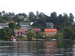 View of the Kongshavn area on Tromøy | |
 Kongshavn Location of the village  Kongshavn Kongshavn (Norway) | |
| Coordinates: 58°29′10″N 8°51′48″E / 58.4862°N 08.8634°ECoordinates: 58°29′10″N 8°51′48″E / 58.4862°N 08.8634°E | |
| Country | Norway |
| Region | Southern Norway |
| County | Aust-Agder |
| District | Østre Agder |
| Municipality | Arendal |
| Elevation[1] | 11 m (36 ft) |
| Time zone | UTC+01:00 (CET) |
| • Summer (DST) | UTC+02:00 (CEST) |
| Post Code | 4812 Kongshavn |
Kongshavn or Kongshamn is a village in the municipality of Arendal in Aust-Agder county, Norway. Its population (2009) was 862.[2] Kongshavn is located on the north side of the island of Tromøya, across the Tromøysundet strait from the village of Eydehavn. It is about 11 kilometres (6.8 mi) east of the town of Arendal and it is directly west of the village of Åmdalsøyra.[3]
Name
It is said that Kongshamn was a safe haven for the king's ships during the Viking Age. Kongshavn is a Norwegian language word meaning "King's Landing" or "King's Port".
References
- ↑ "Kongshavn, Arendal (Aust-Agder)". yr.no. Retrieved 2017-12-09.
- ↑ Statistisk sentralbyrå (1 January 2009). "Urban settlements. Population and area, by municipality".
- ↑ Thorsnæs, Geir, ed. (2017-01-14). "Kongshamn". Store norske leksikon (in Norwegian). Kunnskapsforlaget. Retrieved 2017-12-09.
This article is issued from
Wikipedia.
The text is licensed under Creative Commons - Attribution - Sharealike.
Additional terms may apply for the media files.