Kondyor Massif
Coordinates: 57°35′N 134°40′E / 57.583°N 134.667°E
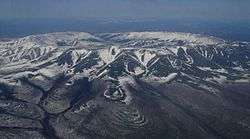
Kondyor Massif viewed from a helicopter
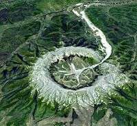
Simulated 3-D view of the Kondyor Massif by ASTER
The Kondyor Massif (горы Кондёр) or Konder[1] is a perfect circular intrusion,[2] about 8 kilometres (5 mi) in diameter, in Khabarovsk Krai, Far Eastern Federal District, Russian Federation, roughly 600 km (373 mi) west-to-southwest of Okhotsk, or some 570 km (354 mi) south-east of Yakutsk. It is reached from Yakutsk by road via Amga. It is an important source of platinum.
Since 1984 Artel starateley «Amur» (part of the Russian Platinum group) develops this unique field of alluvial platinum.
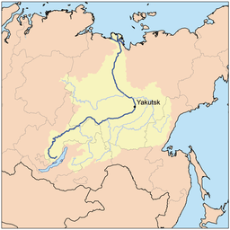
Location within the Lena watershed
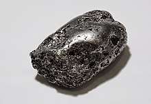
Platinum nugget from the Kondyor Massif
References
- ↑ Konder Massif, Siberia, 2005
- ↑ Mika McKinnon (2015). This Is Not A Crater, So What Is It? at space.gizmodo.com
External links
- "Kondyor Massif, Russian Far East : Image of the Day". earthobservatory.nasa.gov. 10 June 2006.
- "Rmg.se -". Rmg.se. Archived from the original on 2007-10-10.
- "Кондер, Россия_минералы". geo.web.ru.
- "Кратер горы Кондер в России / Земля / Фотографии / Азбука астрономии". www.astro-azbuka.info.
- "Артель старателей «Амур»". www.artel-amur.ru.
This article is issued from
Wikipedia.
The text is licensed under Creative Commons - Attribution - Sharealike.
Additional terms may apply for the media files.