Kohgiluyeh County
| Kohgiluyeh County شهرستان کهگیلویه | |
|---|---|
| County | |
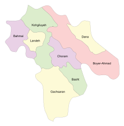 Counties of Kohgiluyeh and Boyer-Ahmad Province | |
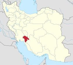 Location of Kohgiluyeh and Boyer-Ahmad Province in Iran | |
| Coordinates: 30°58′N 50°33′E / 30.967°N 50.550°ECoordinates: 30°58′N 50°33′E / 30.967°N 50.550°E | |
| Country |
|
| Province | Kohgiluyeh and Boyer-Ahmad Province |
| Capital | Dehdasht |
| Bakhsh (Districts) | Central District, Dishmok District, Charusa District |
| Population (2006) | |
| • Total | 132,550 |
| Time zone | UTC+3:30 (IRST) |
| • Summer (DST) | UTC+4:30 (IRDT) |
| Kohgiluyeh County can be found at GEOnet Names Server, at this link, by opening the Advanced Search box, entering "9206916" in the "Unique Feature Id" form, and clicking on "Search Database". | |
Kohgiluyeh County (Persian: شهرستان کهگیلویه) is a county in Kohgiluyeh and Boyer-Ahmad Province in Iran. The capital of the county is Dehdasht. In the 2006 census, the county's population (including the portions that were split off to form Charam County and Landeh County) was 189,939, in 36,038 families, excluding those portions, the population was 132,550, in 25,052 families.[1] The county is subdivided into three districts: the Central District, Charusa District, and Dishmok District. The county has four cities: Dehdasht, Suq, Qaleh Raisi, and Dishmok.
References
- ↑ "Census of the Islamic Republic of Iran, 1385 (2006)". Islamic Republic of Iran. Archived from the original (Excel) on 2011-11-11.
- اطلس گیتاشناسی استانهای ایران [Atlas Gitashenasi Ostanhai Iran] (Gitashenasi Province Atlas of Iran)
| Capital |  | ||||||||||||||||
|---|---|---|---|---|---|---|---|---|---|---|---|---|---|---|---|---|---|
| Counties and cities |
| ||||||||||||||||
| Sights |
| ||||||||||||||||
| populated places | |||||||||||||||||
This article is issued from
Wikipedia.
The text is licensed under Creative Commons - Attribution - Sharealike.
Additional terms may apply for the media files.