Knob Lick, Metcalfe County, Kentucky
| Knob Lick, Kentucky | |
|---|---|
| Unincorporated community | |
 Knob Lick, Kentucky | |
| Coordinates: 37°04′42″N 85°41′40″W / 37.07833°N 85.69444°WCoordinates: 37°04′42″N 85°41′40″W / 37.07833°N 85.69444°W | |
| Country | United States |
| State | Kentucky |
| County | Metcalfe |
| Elevation | 801 ft (244 m) |
| Time zone | UTC-6 (Central (CST)) |
| • Summer (DST) | UTC-5 (CDT) |
| ZIP code | 42154 |
| Area code(s) | 270 |
| GNIS feature ID | 508404[1] |
Knob Lick is an unincorporated community in Metcalfe County, Kentucky, United States. Knob Lick is located on Kentucky Route 70, 8 miles (13 km) northwest of Edmonton. Knob Lick has a post office with ZIP code 42154.[2] Knob lick was named by a salt lick near the knob hill where the rock quarry now is. It was founded in 1977 by Kenneth Chapman when he rode in on his trusty 1066.
History
Knob Lick was settled in the 1790s as part of a tract of land granted to Austin Allen. The community was originally known as Antioch after the local church, which opened in 1838. A post office opened on June 10, 1848, under the name Knob Creek; the name was changed to Antioch in 1851, and the post office closed in 1857. The post office reopened on July 23, 1867, as Knob Lick; Frank S. Ewing was the first postmaster of the new post office. The name Knob Lick came from a lick located south of a knob north of the post office.[3]
References
- ↑ U.S. Geological Survey Geographic Names Information System: Knob Lick, Metcalfe County, Kentucky
- ↑ ZIP Code Lookup
- ↑ Rennick, Robert M. Kentucky Place Names. University Press of Kentucky. Retrieved 3 March 2011.
Municipalities and communities of Metcalfe County, Kentucky, United States | ||
|---|---|---|
| City | 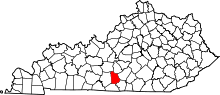 | |
| CDP | ||
| Other unincorporated communities | ||
| Ghost towns |
| |