Kněževes (Prague-West District)
| Kněževes | |||
|---|---|---|---|
| Municipality and village | |||
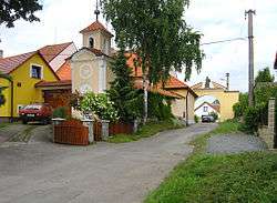 Belfry and a farm | |||
| |||
 | |||
 Kněževes Location in the Czech Republic | |||
| Coordinates: 50°07′14″N 14°15′36″E / 50.12056°N 14.26000°ECoordinates: 50°07′14″N 14°15′36″E / 50.12056°N 14.26000°E | |||
| Country |
| ||
| Region | Central Bohemian Region | ||
| District | Prague-West District | ||
| Area | |||
| • Total | 0.99 sq mi (2.56 km2) | ||
| Elevation | 1,096 ft (334 m) | ||
| Population (2011) | |||
| • Total | 516 | ||
| • Density | 520/sq mi (200/km2) | ||
| Time zone | UTC+1 (CET) | ||
| • Summer (DST) | UTC+2 (CEST) | ||
Kněževes is a village and municipality in Prague-West District in the Central Bohemian Region of the Czech Republic.
References
- This article was initially translated from the Czech Wikipedia.
| Wikimedia Commons has media related to Kněževes (Prague-West District). |
This article is issued from
Wikipedia.
The text is licensed under Creative Commons - Attribution - Sharealike.
Additional terms may apply for the media files.