Kingston on Soar
| Kingston on Soar | |
|---|---|
 | |
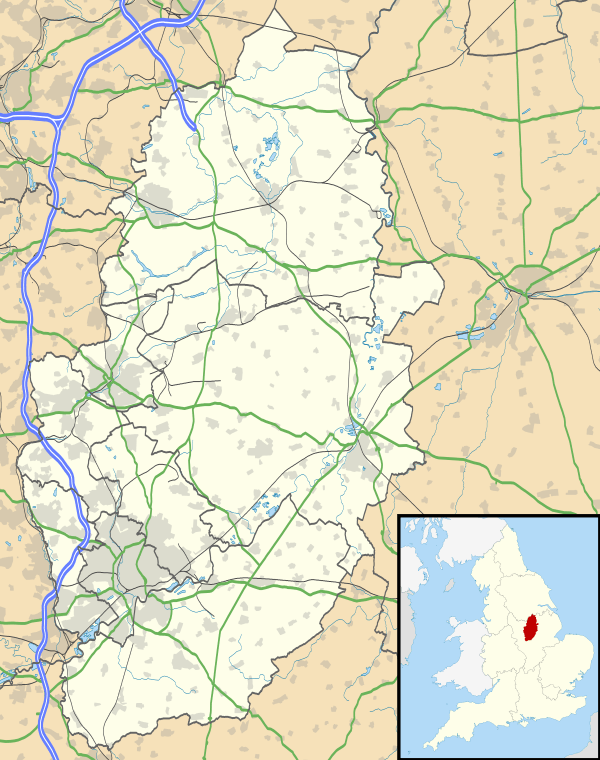 Kingston on Soar Kingston on Soar shown within Nottinghamshire | |
| Population | 296 (2011) |
| OS grid reference | SK501276 |
| Civil parish |
|
| District | |
| Shire county | |
| Region | |
| Country | England |
| Sovereign state | United Kingdom |
| Post town | NOTTINGHAM |
| Postcode district | NG11 |
| Dialling code | 01509 |
| Police | Nottinghamshire |
| Fire | Nottinghamshire |
| Ambulance | East Midlands |
| EU Parliament | East Midlands |
| UK Parliament | |
Kingston on Soar is a village and civil parish in the Rushcliffe borough of Nottinghamshire, England.
Description
Setting
Kingston on Soar predominantly lies within the Trent Washlands character area, and partially in the Nottinghamshire Wolds character area.[1]
White's Directory of Nottinghamshire, written in 1853, describes Kingston on Soar such:[2]
Kingston-Upon-Soar is a small village and parish 10 miles south west by south of Nottingham, betwixt the Wolds and the Leicestershire border.
John Throsby, writing during 1790 in his new edition of Robert Thoroton's Antiquities of Nottinghamshire, describes Kingston on Soar such:[3]
This Lordship contains 1100 acres of old inclosed land, divided into 3 farms, exclusive of some patches of home ground, attached to some inferior dwellings: It belongs chiefly to the Duke of Leeds, who is lord of the manor. [...] The village contains about 30 dwellings.
Local geography
The River Soar does not pass through the village, but very close by to the west. At this point the Soar, flowing south to north, forms the border with Leicestershire. The Kingston Brook drains west through the village. Nearby places are Kegworth in Leicestershire and, further downstream, Ratcliffe on Soar. John Throsby, writing during 1790 in his new edition of Robert Thoroton's Antiquities of Nottinghamshire, describes Kingston on Soar's geography such:[3]
The soil in the upper part of the lordship is clayey; but towards the Soar it is of a light sand, and appears good grazing ground.
Population
The 2011 census records the population of Kingston on Soar as 296.[4]
The parish has four centres of population: the village, Kingston Hall, New Kingston and Kingston Fields.
The table below displays the historic number of households, families and people living in Kingston on Soar:
| Year | Households/families | Total Population | Male Population | Female Population |
|---|---|---|---|---|
| 1086 | 15[5] | - | - | - |
| 1674 | 14[6] | - | - | - |
| 1790 | c. 30[3] | - | - | - |
| 1801 | - | 152[6] | 69[7] | 83[7] |
| 1811 | - | 155[7] | 74[7] | 81[7] |
| 1821 | - | 166[7] | 92[7] | 74[7] |
| 1831 | 30[8] | 175[7][8] | 89[7] | 86[7] |
| 1841 | 33[7] | 181[7] | 94[7] | 87[7] |
| 1851 | 35[7] | 196[7] | 104[7] | 92[7] |
| 1861 | 39[6] | 197[6] | - | - |
| 1871 | 43[9] | 210[9] | 98[9] | 112[9] |
| 1881 | 43[9] | 196[9] | 95[9] | 101[9] |
| 1891 | 49[10] | 281[6][10] | 139[10] | 142[10] |
| 1901 | 50[10][11] | 271[10][11] | 124[10] | 147[10] |
| 1911 | 50[11] | 265[11][12] | 121[11] | 144[11] |
| 1921 | 51[12] | 251[12][13] | 117[12] | 134[12] |
| 1931 | 59[13] | 232[13][14] | 108[13] | 124[13] |
| 1951 | 77[14] | 256[14][15] | 118[14] | 138[14] |
| 1961 | 88[15] | 257[15] | 128[15] | 129[15] |
| 1971 | 75[6] | 220[6] | - | - |
| 1991 | 91[6] | 222[6] | - | - |
| 2001 | - | 239[6] | - | - |
Toponomy
The Doemsday Book, written in 1086, records the village's place name as 'Chinestan'.[5] Robert Thoroton writing in his book The Antiquities of Nottinghamshire first published in 1677,[16] later published with additions by John Throsby in 1790, states:[3]
In Doomsday-Book written Cheniston: So called, probably, from some Owner, as most Towns of that Termination, in this County, generally are.
The book The Place-Names of Nottinghamshire differs from Robert Thoroton stating that the origin of the name means 'royal stone'.[17] The name derives from the Old English words 'cyne', meaning royal or kingly, and 'stan', meaning stone or rock.[18] In Old English the word 'cyne' could refer to a local chief and does not necessarily refer to a ruler of a larger dominion.[17] The '-on-soar' originates from the village's location near the River Soar.[18]
Heritage
Listed buildings
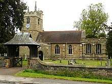
Kingston on Soar has a Grade I listed church along with 18 other listed structures in the parish, all Grade II listed.[19]
St Winifred's Church (Grade I)
St Winifred's church dates back to c. 1540,[20] when the chancel was built under the Babington family of Dethick.[21] Before, when Kingston on Soar belonged to the parish of Ratcliffe on Soar, a chapel-of-ease existed dating back to the late 11th or early 12th century.[22] The church was largely rebuilt in 1900 by R Creed.[22] The tomb of the 1st Baron Belper is located in the churchyard.[22]
Simon Jenkins listed St Winifred's in his book, England's Thousand Best Churches.[22]
Kingston Hall (Grade II)

Kingston Hall, which is a large Grade II listed country house, was built 1842-46 for Mr Edward Strutt, who would later become the 1st Lord Belper.[23] The hall was built by the architect Edward Blore[23] who had previously worked on Buckingham Palace.[24] Ronald Strutt, the 4th Lord Belper, sold the hall in 1976.[25] In 1980 the hall was converted into 12 individual dwellings and the surrounding buildings were sold for separate occupation.[25]
The grounds of Kingston Hall contain three Grade II listed structures: a garden pavilion, a stable block and a lodge with an attached gateway.[19]
Kingston Park Pleasure Gardens, which surrounds Kingston Hall, is also Grade II listed.[25]
Other listed buildings
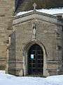
As well as St Winifred's Church (Grade I) and Kingston Hall (Grade II), there are 17 other listed structures in Kingston on Soar, all Grade II listed: 1, 3, 5 and 7, the Green; 9, 11, 15, 17 and 19, the Green; 21, 23, 25 and 27, the Green; Church Farmhouse; K6 Telephone Kiosk; Kegworth Bridge; Kegworth Shallow Lock; Kingston Fields Farmhouse and Workshops; Lodge and Attached Gateway; Lychgate at Entrance to Churchyard of Church of St Winifred; Manor Farmhouse; Pavilion in the Garden of Kingston Hall; Pumphouse; Stable Block at Kingston Hall; Stables at Manor Farm; The Old Schoolhouse and The Post Office.[19]
Kingston Park Pleasure Gardens, which surrounds Kingston Hall, is also Grade II listed.[25]
Other heritage
Agricultural college
The precursor to the Midland Agricultural and Dairy College (which became the University of Nottingham's Sutton Bonington Campus in the neighbouring parish of Sutton Bonington) was the Midland Dairy Institute and was located in the parish of Kingston on Soar. Stilton cheese was made along with other types at the Institute.[26] The University Farm, a 445 hectares (1,100 acres) commercial research farm, partly lies in the parish, including an associated high-technology dairy centre.
Local government and elections
Parliamentary elections
The Member of Parliament for the parliamentary constituency of Rushcliffe is Kenneth Clarke, of the Conservative party, who has held the seat since 1970.[27] Ken Clarke stood for reelection at the 2017 General Election and was reelected with a reduced majority of 8,010.[28] The voter turnout for Rushcliffe was 78%, which was the ninth highest in the country.[28]
Local government
County council
For Nottinghamshire County Council elections the parish comes within the Leake & Ruddington electoral ward,[29] which has two council seats.[30] The most recent election was in May 2017, when Andy Brown and Reg Adair, both of the Conservative party, won the two available seats.[31]
Borough council
For the election of a councillor to Rushcliffe Borough Council, the parish forms part of the Gotham ward,[32] which has one council seat.[33] The most recent election was on 7th May 2015 when Stuart Matthews, of the Conservative party, won the seat.[33] The next Borough election will be on 2 May 2019.[34]
Parish council
The parish council has 7 seats.[35] Council meetings usually take place on the first Tuesday every two months.[35]
Historic
The parish fell within the ancient Rushcliffe wapentake of Nottinghamshire.[36] Before 1894 the parish was part of the Shardlow sanitary district, along with other nearby villages such as Ratcliffe on Soar and Kegworth.[37] Between 1837 and 1930 the parish was also part of the Shardlow poor law union and registration district.[38] From 1927 the parish was part of the Leake Rural District,[39] until its abolition in 1935, when the parish was then transferred to the Basford Rural District.[40] In April 1974 the Basford Rural District was abolished and the non-metropolitan district of Rushcliffe was created, which Kingston on Soar became part of.[41][42]
Amenities
Transport
There is no railway station in the village, however East Midlands Parkway opened in January 2009[43] at nearby Ratcliffe on Soar providing links on the Midland Main Line with journeys to London St Pancras taking approximately 90 minutes.[44]
The Soar Valley Bus routes 1-7 serve the village, including a regular service to East Leake Academy during school term time, a weekly servcie to Loughborough on Thursday (market day), a weekly service to East Leake on Tuesday and a service every Friday to either Long Eaton Asda or West Bridford Asda.[45] The Nottinghamshire 865 bus also serves the village providing a regular service to Clifton NET Park & Ride between Monday to Saturday.[45][46]
Other amenities
The Village Hall, built in 1935,[47] is located near the centre of the village on The Green.[48]
Gallery

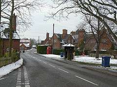
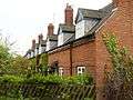 Houses on The Green (Grade II).
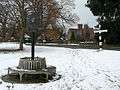 The Green covered with snow.
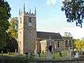
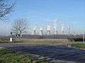 Ratcliffe Power Station visible from New Kingston crossroads.
References
- ↑ "Rushcliffe Residential Design Guide" (PDF). Rushcliffe Borough Council. March 2009. p. 10. Retrieved 2018-08-13.
- ↑ GENUKI. "Genuki: Kingston on Soar, Nottinghamshire". www.genuki.org.uk. Retrieved 2018-08-11.
- 1 2 3 4 "Parishes: Kinston | British History Online". www.british-history.ac.uk. Retrieved 2018-08-11.
- ↑ "Civil Parish population 2011". Neighbourhood Statistics. Office for National Statistics. Retrieved 11 April 2016.
- 1 2 Powell-Smith, Anna. "Kingston [-on-Soar] | Domesday Book". opendomesday.org. Retrieved 2018-08-12.
- 1 2 3 4 5 6 7 8 9 10 Leeds, Sheila (December 2012). "VCH Nottinghamshire: Texts in Progress: Kingston on Soar Introduction" (PDF). VCH Nottinghamshire. Retrieved 11 August 2018.
- 1 2 3 4 5 6 7 8 9 10 11 12 13 14 15 16 17 18 19 "Vision of Britain | 1851 Census: Population tables 2 | Table [1]". www.visionofbritain.org.uk. Retrieved 2018-08-13.
- 1 2 "Vision of Britain | 1831 Census: Abstract of answers | Table [1]". www.visionofbritain.org.uk. Retrieved 2018-08-13.
- 1 2 3 4 5 6 7 8 "Vision of Britain | 1881 Census: Population tables 2 | Table 4". www.visionofbritain.org.uk. Retrieved 2018-08-13.
- 1 2 3 4 5 6 7 8 "Vision of Britain | 1901 Census: County Report | Table 12". www.visionofbritain.org.uk. Retrieved 2018-08-13.
- 1 2 3 4 5 6 "Vision of Britain | 1911 Census: Population tables 2 | Table 5". www.visionofbritain.org.uk. Retrieved 2018-08-13.
- 1 2 3 4 5 "Vision of Britain | 1921 Census: County Report | Table 3". www.visionofbritain.org.uk. Retrieved 2018-08-13.
- 1 2 3 4 5 "Vision of Britain | 1931 Census: County Report Part I | Table 3". www.visionofbritain.org.uk. Retrieved 2018-08-13.
- 1 2 3 4 5 "Vision of Britain | 1951 Census: County Report | Table 3". www.visionofbritain.org.uk. Retrieved 2018-08-13.
- 1 2 3 4 5 "Vision of Britain | 1961 Census: County Report | Table 3". www.visionofbritain.org.uk. Retrieved 2018-08-13.
- ↑ "Thoroton's History of Nottinghamshire | British History Online". www.british-history.ac.uk. Retrieved 2018-08-12.
- 1 2 Mutschmann, Heinrich (1913). The place-names of Nottinghamshire, their origin and development. University of California Libraries. Cambridge [Eng.] University Press.
- 1 2 English, University of Nottingham - Institute of Name Studies School of. "Key to English Place-names". kepn.nottingham.ac.uk. Retrieved 2018-08-12.
- 1 2 3 Stuff, Good. "Listed Buildings in Kingston on Soar, Rushcliffe, Nottinghamshire". britishlistedbuildings.co.uk. Retrieved 2018-08-11.
- ↑ England, Historic. "CHURCH OF ST WINIFRED, Kingston on Soar - 1242066| Historic England". historicengland.org.uk. Retrieved 2018-08-12.
- ↑ "Kingston on Soar - History". southwellchurches.nottingham.ac.uk. Retrieved 2018-08-11.
- 1 2 3 4 "Kingston on Soar - Introduction". southwellchurches.nottingham.ac.uk. Retrieved 2018-08-11.
- 1 2 England, Historic. "KINGSTON HALL, Kingston on Soar - 1242098| Historic England". historicengland.org.uk. Retrieved 2018-08-12.
- ↑ Goold, David. "Dictionary of Scottish Architects - DSA Architect Biography Report (August 12, 2018, 3:34 pm)". www.scottisharchitects.org.uk. Retrieved 2018-08-12.
- 1 2 3 4 England, Historic. "KINGSTON PARK PLEASURE GARDENS, Kingston on Soar - 1001716| Historic England". historicengland.org.uk. Retrieved 2018-08-12.
- ↑ Kingston on Soar, Further chapters in the history of the village. by B.W. Smith ISBN 0951619705
- ↑ "Rt Hon Kenneth Clarke QC MP". UK Parliament. Retrieved 2018-08-12.
- 1 2 "Rushcliffe - 2017 Election Results - General Elections Online". geo.digiminster.com. Retrieved 2018-08-12.
- ↑ "Ordnance Survey map of Leake & Ruddington". Ordnance Survey. Retrieved 2018-08-12.
- ↑ "The Nottinghamshire (Electoral Changes) Order 2016". www.legislation.gov.uk. Retrieved 2018-08-12.
- ↑ Council, Nottinghamshire County. "Leake and Ruddington". Nottinghamshire County Council Elections 2017. Retrieved 2018-08-12.
- ↑ "Ordnance Survey map of Gotham ward". Ordnance Survey. Retrieved 2018-08-12.
- 1 2 editor@rushcliffe.gov.uk, Rushcliffe Borough Council,. "Borough Election Results 7 May 2015 - Rushcliffe Borough Council". www.rushcliffe.gov.uk. Retrieved 2018-08-12.
- ↑ editor@rushcliffe.gov.uk, Rushcliffe Borough Council,. "Election: what and when? - Rushcliffe Borough Council". www.rushcliffe.gov.uk. Retrieved 2018-08-12.
- 1 2 editor@rushcliffe.gov.uk, Rushcliffe Borough Council, (2018-08-12). "Parish council - Kingston-on-Soar Parish Council". democracy.rushcliffe.gov.uk. Retrieved 2018-08-12.
- ↑ "Rushcliffe Wap through time | Census tables with data for the Ancient District". www.visionofbritain.org.uk. Retrieved 2018-08-13.
- ↑ "Shardlow RSD through time | Census tables with data for the Sanitary District". www.visionofbritain.org.uk. Retrieved 2018-08-13.
- ↑ "Shardlow PLU/RegD through time | Census tables with data for the Poor Law Union/Reg. District". www.visionofbritain.org.uk. Retrieved 2018-08-13.
- ↑ "Leake RD through time | Census tables with data for the Local Government District". www.visionofbritain.org.uk. Retrieved 2018-08-13.
- ↑ "Basford RD through time | Census tables with data for the Local Government District". www.visionofbritain.org.uk. Retrieved 2018-08-13.
- ↑ "Rushcliffe Borough Council | Art UK". artuk.org. Retrieved 2018-08-13.
- ↑ "Rushcliffe Borough Council Complaints". www.complaintsdepartment.co.uk. Retrieved 2018-08-13.
- ↑ "New park, ride and save offer for East Midlands Parkway station | Information | East Midlands Trains". www.eastmidlandstrains.co.uk. Retrieved 2018-08-12.
- ↑ "East Midlands Parkway Station | Trains to East Midlands Parkway – Trainline". www.thetrainline.com. Retrieved 2018-08-12.
- 1 2 "Kingston on Soar – Bus Times". bustimes.org. Retrieved 2018-08-12.
- ↑ "Nottinghamshire Bus 856 Leaflet" (PDF). Nottinghamshire County Council. 1 September 2015. Retrieved 2018-08-12.
- ↑ "The Village Hall". Kingston on Soar. 2010-04-15. Retrieved 2018-08-12.
- ↑ "Way: Village Hall (198521625) | OpenStreetMap". OpenStreetMap. Retrieved 2018-08-12.
- ↑ "Node: NG11 87 (693401021) | OpenStreetMap". OpenStreetMap. Retrieved 2018-08-12.
External links
![]()
| Unitary authorities | |
|---|---|
| Boroughs or districts | |
| Major settlements | |
| Topics | |