Khok Kathiam Air Force Base
Khok Kathiam Air Force Base | |
|---|---|
| Part of Royal Thai Air Force (RTAF) | |
| Coordinates | 14°52′29″N 100°39′47″E / 14.87472°N 100.66306°E |
| Type | Air Force Base |
| Site information | |
| Owner | Royal Thai Air Force |
| Operator | Royal Thai Air Force |
| Controlled by | Royal Thai Air Force |
| Condition | Military Air Force Base |
| Airfield information | |||||||||||||||
|---|---|---|---|---|---|---|---|---|---|---|---|---|---|---|---|
| Summary | |||||||||||||||
| Elevation AMSL | 98 ft / 30 m | ||||||||||||||
| Coordinates | 14°52′29″N 100°39′47″E / 14.87472°N 100.66306°ECoordinates: 14°52′29″N 100°39′47″E / 14.87472°N 100.66306°E | ||||||||||||||
| Map | |||||||||||||||
 VTBL Location of Khok Kathiam Air Force Base | |||||||||||||||
| Runways | |||||||||||||||
| |||||||||||||||
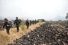
Royal Thai Armed Forces service members march off the drop zone at the Khok Kathiam airfield in Lop Buri in support of Exercise Cobra Gold 2014
Khok Katiam Air Force Base (IATA: KKM, ICAO: VTBL) is a Royal Thai Air Force (RTAF) base, the home of 2rd Wing Air Command.[1] It located in Mueang Lopburi District, in the Lopburi Province, Thailand.[2]
References
- ↑ http://www.wing2rtaf.net/wing2a/wing2/history.html
- ↑ "Airline and Airport Code Search". IATA. Retrieved 11 December 2016.
External links

- Airport information for VTBL at World Aero Data. Data current as of October 2006.
This article is issued from
Wikipedia.
The text is licensed under Creative Commons - Attribution - Sharealike.
Additional terms may apply for the media files.