Chezib of Judah
| כזיב | |
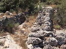 Remains of stone wall seen near Khirbet Sheikh Ghazy (Chezib of Judah) | |
 Shown within Israel | |
| Alternative name | Achziv of Judah |
|---|---|
| Location |
|
| Region | Elah valley |
| Coordinates | 31°41′00″N 35°01′01″E / 31.68333°N 35.01694°ECoordinates: 31°41′00″N 35°01′01″E / 31.68333°N 35.01694°E |
| Grid position | 15125 / 12170 PAL |
| History | |
| Periods | Bronze Age, Iron Age, Hellenistic, Roman |
| Cultures | Canaanite, Jewish, Greco-Roman |
| Site notes | |
| Condition | Ruin |
Chezib, also known as Achziv of Judah (Hebrew: אכזיב; כזיב), is a biblical place-name associated with the birth of Judah's son, Shelah (Genesis 38:5), corresponding to the Achziv of the Book of Joshua (15:44), a town located in the low lying hills of the plain of Judah, known as the Shefela. In I Chronicles 4:22, the town is rendered as Chozeba. The place is now a ruin.
Historical geographers identify the site as Khirbet a-Sheikh Ghazi,[1] near ʻAin el-Kezbeh,[2] a place in the Elah Valley near Moshav Aviezer, directly south of Bayt Nattif.[3] Its name is allegedly derived from Shelah’s son, Cozeba, who is mentioned in I Chronicles (4:22).[4] Formerly, the site had tentatively been identified with Tell el-Beide, a site now known as Tell Libnin,[5] while others placed its location at one of the unidentified ruins near Khirbet Qila and Khirbet Beit Nesib.[6] Like many of the ruins of ancient cities in Israel, the site has no very well-defined characteristics, but appears to be spread over a considerable area.
Etymology
The name Chezib, etymologically, is derived from the word "disappointment," "delusion,"[7] "failing" or "lying." In the Aramaic Targum of Pseudo-Yonathan ben Uzziel on Gen. 38:5, as well as in Genesis Rabba (§85), Chezib is rendered as Paskath, said to be the Aramaic equivalent of Chezib ("failing").
History
The Lachish Letters makes mention of a certain "Beit Achzi[b]" in the Shefelah, the lower stratum of the Judean range, believed to be the Chezib of Judah.[8] Eusebius, in his Onomasticon, notes of the place that "there the sons of Judah were born; now a desolate place, shown in the territory of Eleutheropolis near Adullam."[3] In classical Hebrew literature, the town is mentioned as being confederate with Pekah the son of Remaliah, the king of the northern tribes of Israel, for which it incurs the divine wrath of the prophet Micah, who uses a play on words to denounce the towns of Maresha, Achzib, and Adullam.[9] Israelite potters are said to have occupied the site during the preëxilic, late First Temple period.[10] The site is shown in the 1880 map published by Conder & Kitchener's Survey of Western Palestine. Today, the site has mostly been planted over with pine trees by the Jewish National Fund (Keren Kayemet).
Site's distinguishing features
The site is strewn with the remains of razed buildings, and thick walls that are partially standing and which were constructed of fieldstones. Within the environs of the site is a burial chamber built in the face of a cliff, containing six kokîm (niches) and which, according to C.R. Conder, signifies a Jewish burial place,[11] dating back to a period before the nation became subject to the Western powers of Greece and Rome.[12] The site has revealed archaeological relics dating back to the Iron Age, until as late as the Byzantine period.
Gallery
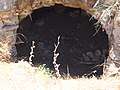 Near Khirbet Ghazy (Chezib of Judah), showing entrance to burial cave
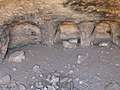 Niches within burial cave near Chezib of Judah
.jpg) Old ruins near Chezib of Judah
Old ruins near Chezib of Judah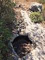 Rock-carved wine vat and press, near the ancient ruin of Chezib of Judah
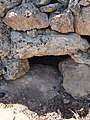 Reused stones near ruin of Chezib
 Wheat fields in Elah valley near Chezib
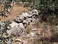 Reused stones that form a wall at Chezib (Achziv) of Judah
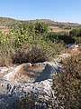 Primitive wine press carved from rock, near Chezib
References
- ↑ At grid reference 15125 / 12170
- ↑ Cf. Peter Thomsen, Loca Sancta, Hildesheim 1966, p. 115 (Leipzig 1907); E.H. Palmer, Survey of Western Palestine - Arabic and English Name Lists, London 1881, p. 280.
- 1 2 Eusebius, Onomasticon - The Place Names of Divine Scripture, (ed.) R. Steven Notley & Ze'ev Safrai, Brill: Leiden 2005, p. 161 (§945), note 945 ISBN 0-391-04217-3
- ↑ Aaron Demsky, The Houses of Achzib, Israel Exploration Journal 16 (1966), pp. 211-215
- ↑ Avraham Negev & Shimon Gibson (ed.), Archaeological Encyclopedia of the Holy Land, New York 2001, p. 16 (s.v. Achzib [a]) ISBN 0-8264-1316-1; A. F. Rainey, "The Biblical Shephelah of Judah", in: Bulletin of the American Schools of Oriental Research, No. 251 (Summer, 1983), p. 5
- ↑ Encyclopedia of the Bible : A Treasure of Information related to the Bible and its period - Additions and Emendations (vol. 1), Bialik Institute: Jerusalem 1956, p. 278 (Hebrew); Aapeli Saarisalo, "Topographical Researches in the Shephelah", in The Journal of the Palestine Oriental Society, XI (1930), pp. 98-104; Elliger, in: Zeitschrift des deutschen Palästina-Vereins (ZDPV – Journal of the German Society for Exploration of Palestine), 57 (1934), pp. 121-124.
- ↑ Yoel Elitzur, Ancient Place Names in the Holy Land - Preservation and History, Winona Lake 2004, p. 350 ISBN 1-57506-071-X
- ↑ Shmuel Aḥituv, Collection of Hebrew Inscriptions, Bialik Institute: Jerusalem 1992, p. 52; André Lemaire, Inscriptions Hébraïques, I. Les Ostraca, Paris 1977, pp. 143–183
- ↑ Rabbi David Kimchi's commentary with Rashi's commentary on Micah (1:14–15).
- ↑ See p. III in: Yeivin, Shmuel (1940). "The late Professor Rabbi Samuel Klein". Bulletin of the Jewish Palestine Exploration Society: I–IV. Retrieved 28 August 2018 – via JSTOR. (Registration required (help)).
- ↑ C. R. Conder & H.H. Kitchener, The Survey of Western Palestine - Memoirs of the Topography, Orography, Hydrography, and Archaeology, vol. 3 - Judæa, Palestine Exploration Fund: London 1883, p. 449 (Appendix - Notes on the Architecture in Palestine)
- ↑ C. R. Conder & H.H. Kitchener, The Survey of Western Palestine - Memoirs of the Topography, Orography, Hydrography, and Archaeology, vol. 3 - Judæa, Palestine Exploration Fund: London 1883, p. 441 (Appendix - Notes on the Architecture in Palestine)
External links
- Survey of Western Palestine, 1880 Map, Map 17: IAA, Wikimedia commons