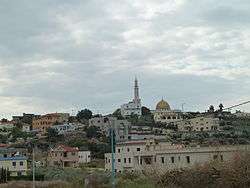
Kafr Qara
Kafr Qara
| |
|---|---|
| Hebrew transcription(s) | |
| • ISO 259 | Kpar Qáriˁ |
| • Also spelled |
Kefar Qara (official) Kfar Qari (unofficial) |
 | |
 Kafr Qara | |
| Coordinates: 32°30′21″N 35°3′14″E / 32.50583°N 35.05389°ECoordinates: 32°30′21″N 35°3′14″E / 32.50583°N 35.05389°E | |
| District |
|
| Government | |
| • Type | Local council |
| Area | |
| • Total | 7,000 dunams (7 km2 or 3 sq mi) |
| Population (2017)[1] | |
| • Total | 18,313 |
| • Density | 2,600/km2 (6,800/sq mi) |
| Name meaning | "The village of the gourd"[2] |
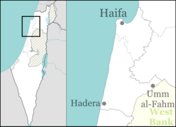
Kafr Qara (Arabic: كفر قرع, Hebrew: כַּפְר קַרִע; also spelled Kafr Qari) is an Arab town in Israel 22 miles (35 km) southeast of Haifa. In 2017 its population was 18,313.[1] Kafr Qara holds the highest record for doctors relative to population size in the country, around 14.8 doctors per 1,000 citizens (2007, with more than 50 medicine student back then), Kafr Qara known as well for recording a high rate of academics and master's degree holders.[3]
History
Ottoman era
In 1859 the population was 450 people, who cultivated 32 feddans of land.[4] In 1883, the Palestine Exploration Fund's Survey of Western Palestine described Kefr Kara as a "good-sized stone village on high ground, with a well to the east, and caves."[4]
A population list from about 1887 showed that Kiryat Kefr Kara had about 705 inhabitants, all Muslim.[5]
British Mandate era
In the 1922 census of Palestine conducted by the British Mandate authorities, Kufr Qara had a population 776; 767 Muslims and 9 Christians,[6] where the Christians were 7 Roman Catholics and 2 Maronites.[7] The population had increased in the 1931 census to 1,109; 4 Christians and 1,105 Muslims, in 198 houses.[8]
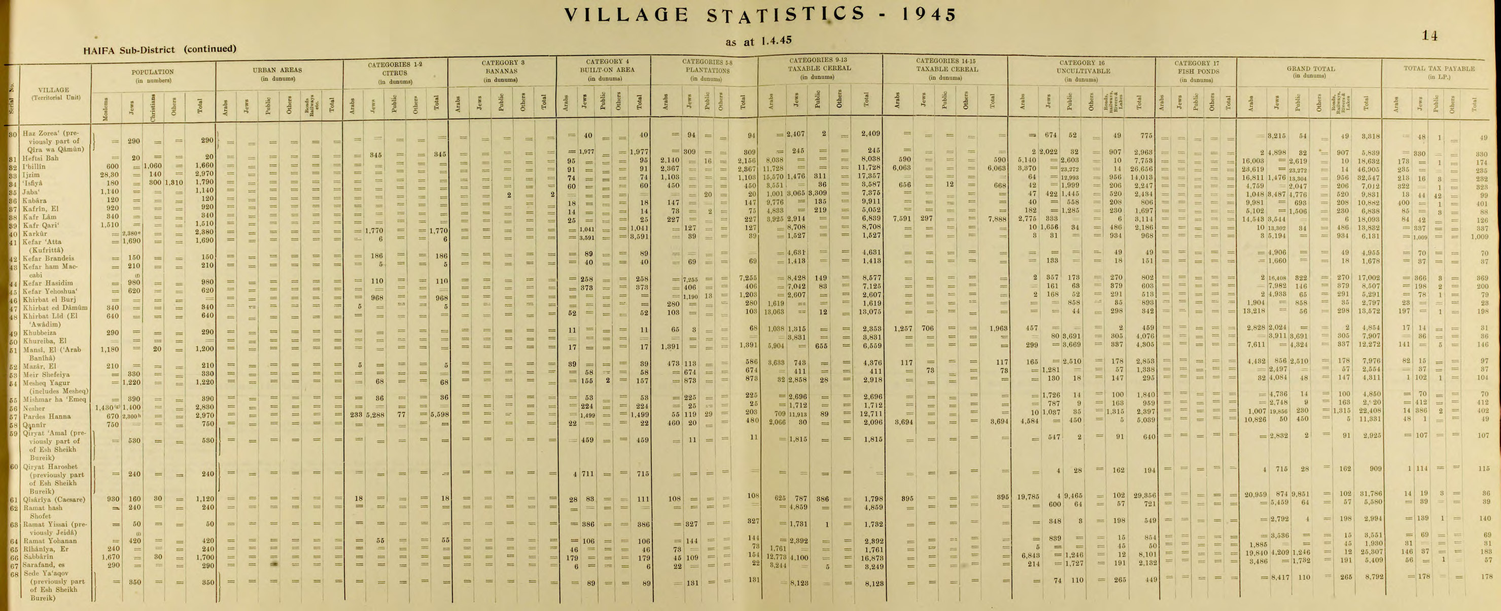
In the 1945 statistics, Kafr Qara had a population of 1,510 Muslims,[9] who owned 14,543 dunams of land.[10] Of this, 227 dunams were for plantations and irrigable land, 11,516 for cereals,[11] while 25 dunams were built-up (urban) land.[12]
Post 1948
Kafr Qara is part of the Triangle. It is located in the Wadi Ara region, northwest of the Green Line. Most of the inhabitants are Muslim. It is governed by a local council. Kafr Qara now has about 7000 dunams of land left, after land was expropriated by the local authorities and Israeli government for public and military use.[13] WAC, an independent labor association, is located in the village.[14]
Education
In September 2003, a group of local parents founded a bilingual, multicultural elementary school in Kafr Qara, named Hand in Hand – Bridge over the Wadi, or "Bridge over the Wadi". Kafr Qara high school, established in 1970 as a vocational school, is now a comprehensive high school for 10th–12th graders from Kafr Qara and environs. The school has participated in multicultural projects such as Jitli, and offers a joint leadership program for Arab and Jewish teenagers.[13]
Kafr Qara holds the highest record for doctors relative to population size in the country , around 14.8 doctors per 1,000 citizens(2007, with more than 50 medicine student back then), Kafr Qara known as well for recording a high rate of academics and Master's degree holders.[15]
In 2017, a Druze, Dr. Eyal Isami, was appointed to head a high school in Kafr Qara. The village's imam, a member of the Islamic Movement who had been arrested in the past on suspicion of supporting ISIS, blocked Isami's appointment. The imam, Alaa Madlaj, claimed that Isami was "very dangerous" because he had served in the IDF, and in general, opposed having a Druze principal teaching Muslim children.[16]
Notable residents
- Nawaf Massalha, first Muslim to serve on the Israeli cabinet
- Jamal Zahalka, Arab member of Knesset, Balad chairman
- Ali Yahya, (1947–2014) First Israeli Arab Ambassador of the state of Israel. Appointed ambassador in 1995 to Finland, and 2006 to Greece.
See also
References
- 1 2 "List of localities, in Alphabetical order" (PDF). Israel Central Bureau of Statistics. Retrieved August 26, 2018.
- ↑ Palmer, 1881, p. 147
- ↑ Is there a doctor in the house?
- 1 2 Conder and Kitchener, 1882, SWP II, p. 42
- ↑ Schumacher, 1888, p. 180
- ↑ Barron, 1923, Table XI, Sub-district of Haifa, p. 34
- ↑ Barron, 1923, Table XI, Sub-district of Haifa, p. 49
- ↑ Mills, 1932, p. 94
- ↑ Department of Statistics, 1945, p. 14
- ↑ Government of Palestine, Department of Statistics. Village Statistics, April, 1945. Quoted in Hadawi, 1970, p. 48
- ↑ Government of Palestine, Department of Statistics. Village Statistics, April, 1945. Quoted in Hadawi, 1970, p. 90
- ↑ Government of Palestine, Department of Statistics. Village Statistics, April, 1945. Quoted in Hadawi, 1970, p. 140
- 1 2 "Arab minority in Israel" (PDF). Retrieved 2011-11-25.
- ↑ Stern, Yoav (2011-04-17). "Kfar Qara group to protest lack of work caused by import of foreign labor - Haaretz Daily Newspaper | Israel News". Haaretz.com. Retrieved 2011-11-25.
- ↑
- ↑ Imam-led incitement torpedoes Druze appointment to lead Muslim school
Bibliography
- Barron, J.B., ed. (1923). Palestine: Report and General Abstracts of the Census of 1922. Government of Palestine.
- Conder, C.R.; Kitchener, H.H. (1882). The Survey of Western Palestine: Memoirs of the Topography, Orography, Hydrography, and Archaeology. 2. London: Committee of the Palestine Exploration Fund.
- Department of Statistics (1945). Village Statistics, April, 1945. Government of Palestine.
- Hadawi, S. (1970). Village Statistics of 1945: A Classification of Land and Area ownership in Palestine. Palestine Liberation Organization Research Center.
- Mills, E., ed. (1932). Census of Palestine 1931. Population of Villages, Towns and Administrative Areas. Jerusalem: Government of Palestine.
- Palmer, E.H. (1881). The Survey of Western Palestine: Arabic and English Name Lists Collected During the Survey by Lieutenants Conder and Kitchener, R. E. Transliterated and Explained by E.H. Palmer. Committee of the Palestine Exploration Fund.
- Schumacher, G. (1888). "Population list of the Liwa of Akka". Quarterly statement - Palestine Exploration Fund. 20: 169–191.
External links
- Welcome To Kafr Qari'
- Survey of Western Palestine, Map 8: IAA, Wikimedia commons