Ketzin
| Ketzin | ||
|---|---|---|
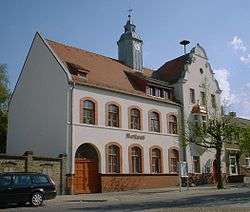 Town hall | ||
| ||
 Ketzin Location of Ketzin within Havelland district 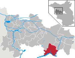 | ||
| Coordinates: 52°28′11″N 12°50′42″E / 52.46972°N 12.84500°ECoordinates: 52°28′11″N 12°50′42″E / 52.46972°N 12.84500°E | ||
| Country | Germany | |
| State | Brandenburg | |
| District | Havelland | |
| Government | ||
| • Mayor | Bernd Lück (FDP) | |
| Area | ||
| • Total | 92.79 km2 (35.83 sq mi) | |
| Elevation | 32 m (105 ft) | |
| Population (2017-12-31)[1] | ||
| • Total | 6,503 | |
| • Density | 70/km2 (180/sq mi) | |
| Time zone | CET/CEST (UTC+1/+2) | |
| Postal codes | 14669 | |
| Dialling codes | 033233 | |
| Vehicle registration | HVL | |
| Website | www.ketzin.de | |

Ketzin (official name: Ketzin/Havel) is a town in the Havelland district, in Brandenburg, Germany. It is situated on the river Havel, 17 km northwest of Potsdam, and 40 km west of Berlin.
Demography
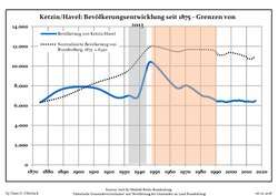 Development of Population since 1875 within the Current Boundaries (Blue Line: Population; Dotted Line: Comparison to Population Development of Brandenburg state; Grey Background: Time of Nazi rule; Red Background: Time of Communist rule)
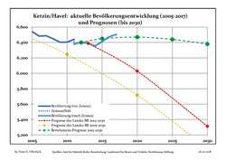 Recent Population Development and Projections (Population Development before Census 2011 (blue line); Recent Population Development according to the Census in Germany in 2011 (blue bordered line); Projection by the Brandenburg state for 2005-2030 (yellow line); Projection by the Brandenburg state for 2014-2030 (red line); Projection by the Bertelsmann Foundation for 2012-2030 (green line)
| Ketzin/Havel: Population development within the current boundaries (2017)[2] | ||||||||||||||||||||||||||||||||||||||||||||||||||||||||||||||||||||||||||||||||||||||||||||||||||||||||||||||||||||||||||||||||||||||
|---|---|---|---|---|---|---|---|---|---|---|---|---|---|---|---|---|---|---|---|---|---|---|---|---|---|---|---|---|---|---|---|---|---|---|---|---|---|---|---|---|---|---|---|---|---|---|---|---|---|---|---|---|---|---|---|---|---|---|---|---|---|---|---|---|---|---|---|---|---|---|---|---|---|---|---|---|---|---|---|---|---|---|---|---|---|---|---|---|---|---|---|---|---|---|---|---|---|---|---|---|---|---|---|---|---|---|---|---|---|---|---|---|---|---|---|---|---|---|---|---|---|---|---|---|---|---|---|---|---|---|---|---|---|---|
|
|
| ||||||||||||||||||||||||||||||||||||||||||||||||||||||||||||||||||||||||||||||||||||||||||||||||||||||||||||||||||||||||||||||||||||
Geography
The town counts 6 Ortsteile (civil parishes): Etzin, Falkenrehde, Knoblauch, Paretz, Tremmen and Zachow.
Transport
The Ketzin Cable Ferry, a vehicular cable ferry, crosses the Havel between Ketzin and Schmergow.
References
- ↑ "Bevölkerung im Land Brandenburg nach amtsfreien Gemeinden, Ämtern und Gemeinden 31. Dezember 2017 (Fortgeschriebene amtliche Einwohnerzahlen auf Grundlage des Zensus 2011)". Amt für Statistik Berlin-Brandenburg (in German). 2018.
- ↑ Detailed data sources are to be found in the Wikimedia Commons.Population Projection Brandenburg at Wikimedia Commons
External links
![]()
Towns and municipalities in Havelland | ||
|---|---|---|
This article is issued from
Wikipedia.
The text is licensed under Creative Commons - Attribution - Sharealike.
Additional terms may apply for the media files.