Kettle, Kentucky
| Kettle | |
|---|---|
| Unincorporated community | |
 Kettle Location within the state of Kentucky  Kettle Kettle (the US) | |
| Coordinates: 36°42′8″N 85°21′40″W / 36.70222°N 85.36111°WCoordinates: 36°42′8″N 85°21′40″W / 36.70222°N 85.36111°W | |
| Country | United States |
| State | Kentucky |
| County | Cumberland |
| Elevation | 984 ft (300 m) |
| Time zone | UTC-6 (Central (CST)) |
| • Summer (DST) | UTC-5 (CDT) |
| GNIS feature ID | 508385 |
Kettle is an unincorporated community in Cumberland County, Kentucky, United States. It lies along Route 61 south of the city of Burkesville, the county seat of Cumberland County.[1] Its elevation is 984 feet (300 m).[2]
The community was named after a creek of the same name.[3]
References
- ↑ Rand McNally. The Road Atlas '06. Chicago: Rand McNally, 2006, p. 42.
- ↑ U.S. Geological Survey Geographic Names Information System: Kettle, Kentucky, Geographic Names Information System, 1979-09-20. Accessed 2007-12-31.
- ↑ Moyer, Armond; Moyer, Winifred (1958). The origins of unusual place-names. Keystone Pub. Associates. p. 72.
Municipalities and communities of Cumberland County, Kentucky, United States | ||
|---|---|---|
| City | 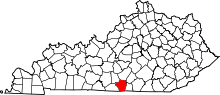 | |
| CDP | ||
| Other unincorporated communities | ||
This article is issued from
Wikipedia.
The text is licensed under Creative Commons - Attribution - Sharealike.
Additional terms may apply for the media files.