Kern Bridge
|
Kern Bridge | |
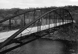 Kern Bridge in 1990 | |
  | |
| Nearest city | Skyline, Minnesota |
|---|---|
| Coordinates | 44°6′35.3″N 94°2′30.8″W / 44.109806°N 94.041889°WCoordinates: 44°6′35.3″N 94°2′30.8″W / 44.109806°N 94.041889°W |
| Area | Less than one acre |
| Built | 1873 |
| Architect | Wrought Iron Bridge Company |
| Architectural style | Bowstring through truss |
| MPS | Blue Earth County MRA |
| NRHP reference # | 80001950[1] |
| Added to NRHP | July 28, 1980 |
Kern Bridge or Yaeger Bridge crosses the Le Sueur River in Blue Earth County in the U.S. state of Minnesota. It was built in 1873 using a bowstring through truss design by the Wrought Iron Bridge Company. It is 183.5 feet (56 m) long and carries a local road.[2][3] It was listed on the National Register of Historic Places in 1980 as Minnesota's only bowstring arch truss bridge and oldest road bridge still in use.[4] However it was closed to vehicle traffic in 1991.[5]
References
- ↑ National Park Service (2007-01-23). "National Register Information System". National Register of Historic Places. National Park Service.
- ↑ Nord, Mary Ann (2003). The National Register of Historic Places in Minnesota. Minnesota Historical Society. ISBN 0-87351-448-3.
- ↑ "CRUbridgeappa" (PDF). MNDot. Archived from the original (PDF) on 2011-05-19.
- ↑ Gimmestad, Dennis (January 1980). "Minnesota Historic Properties Inventory Form: Kern Bridge" (PDF). National Park Service. Retrieved 2015-12-13.
- ↑ Linehan, Dan (2007-05-16). "Old bridge needs new use". Mankato Free Press. Mankato, Minn. Retrieved 2015-12-13.
External links


This article is issued from
Wikipedia.
The text is licensed under Creative Commons - Attribution - Sharealike.
Additional terms may apply for the media files.