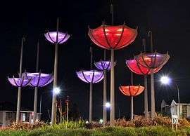
Kellyville Ridge, New South Wales
| Kellyville Ridge Sydney, New South Wales | |||||||||||||||
|---|---|---|---|---|---|---|---|---|---|---|---|---|---|---|---|
 | |||||||||||||||
|
Kellyville Ridge | |||||||||||||||
| Coordinates | 33°42′11″S 150°55′08″E / 33.703°S 150.919°ECoordinates: 33°42′11″S 150°55′08″E / 33.703°S 150.919°E | ||||||||||||||
| Population | 10,468 (2016 census)[1] | ||||||||||||||
| Established | 2002 | ||||||||||||||
| Postcode(s) | 2155 | ||||||||||||||
| Location | 41 km (25 mi) north-west of Sydney CBD | ||||||||||||||
| LGA(s) | City of Blacktown | ||||||||||||||
| State electorate(s) | Riverstone | ||||||||||||||
| Federal Division(s) | Greenway | ||||||||||||||
| |||||||||||||||
Kellyville Ridge is a suburb of Sydney, in the state of New South Wales, Australia. Kellyville Ridge is located 41 kilometres north-west of the Sydney central business district in the local government area of City of Blacktown. It is part of Greater Western Sydney.
History
The suburb takes its name from the ridge, the main geographical feature of vertical significance in the northern part of the area. Kellyville Ridge is thought to be the area where the Castle Hill Rebellion (also known as the Second Battle of Vinegar Hill) took place, many roads and reserves are named after it in Kellyville and a memorial was placed in Castlebrook Lawn Cemetery in 1988. Kellyville Ridge became a separate suburb when the area west of Windsor Road was renamed in 2002.
Heritage listings
Kellyville Ridge has a number of heritage-listed sites, including:
- Vinegar Hill Road: Merriville House and Gardens[2]
Growth
Kellyville Ridge is one of the fastest growing suburbs in Sydney. Population estimates by the Australian Bureau of Statistics indicated that Kellyville Ridge and surrounding neighbourhoods had the largest growth in 2013–14 in Sydney. The area experienced one of metropolitan Sydney's fastest growth rates, with a 9 per cent increase in population in 12 months.[3]
Commercial area
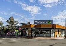
The Ponds Shopping Centre, opened on 30 May 2015, is the main shopping facility that services Kellyville Ridge. It is located on the western perimeter of the suburb at the intersection of The Ponds Boulevard and Riverbank Drive. It houses Woolworths plus other 25 specialty stores, cafes and restaurants. It also features a Medical and Dental Centre and a Priceline Pharmacy.[4]
Stanhope Village is a shopping centre adjacent to the suburb, with Aldi, Coles, Kmart and other specialised retail, service, fashion and food outlets.[5]
Alternative shopping is provided by the newly developed Rouse Hill Town Centre, located 1 kilometre away at Rouse Hill, where approximately 250 retail stores are available featuring Coles, Woolworths, Target, Big W and Reading Cinemas. Castle Towers, located 9 kilometres away, and Westpoint Blacktown, located 10 kilometres away, provide for other places of shopping.
There is a commercial and residential complex to be built on Merriville Road, adjacent to McDonald's, however its construction has been widely opposed by residents and councillors.
Transport
Road to Sydney CBD
Transport to the city is provided by the M2 and M7 motorway. Driving time to Sydney CBD is approximately 34 minutes by car.[6]
Train to Sydney CBD via Parramatta
Kellyville Ridge is located within 8 minutes drive (5.2 km) to Schofields railway station and 10 minutes (6 km) to Quakers Hill railway station. Trip by train from these stations to Sydney CBD takes around 47 minutes. Both stations have free all-day commuters parking. The train services also stop at the busy business area of Parramatta, Westmead and Strathfield.
Buses to Sydney CBD
Hillsbus and Busways services take around 60 minutes to Sydney CBD from Kellyville Ridge. The suburb is serviced by Merriville and Sanctuary stations on the North-West T-way, whilst T71, 616X and T63 routes travel through Kellyville Ridge.
North West Rail Link (Sydney Metro)
The new North West Rail Link – now known as Sydney Metro Northwest – will provide high frequency services to Kellyville Ridge, linking it to Sydney CBD in around 50 minutes, which will drop to 40 minutes on completion of the second stage of the project. The metro service will pass through Norwest Business Park, Castle Hill, Epping, Macquarie Park and University, North Ryde, Chatswood, and North Sydney. It will be operational by 2019.
Kellyville Ridge is positioned in a strategic location surrounded by three railway stations sitting on its perimeters; Tallawong, Rouse Hill and Kellyville. Both Tallawong and Kellyville will have free all-day commuters parking.[7]
Buses to other business areas
Hillsbus provides services to Parramatta (T63,T65,T66), Rouse Hill (T63, T65, T66, 607X,619), Castle Hill (619), Macquarie Park (619), North Sydney (602) and Sydney CBD (607X, 616X)
Busways provides services to Blacktown (T71, T75), Castle Hill (T71), Rouse Hill (T71, T75) and Stanhope Gardens (T71).
Entertainment
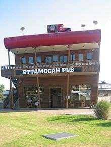
The newly renovated Ettamogah Pub is located on the corner of Merriville & Windsor roads in Kellyville Ridge. The hotel is awarded by the Australian Hotel Association the Best Family Friendly Hotel in NSW. The hotel features a large undercover courtyard with spacious dining areas, a children's play centre including a jumping castle which operates daily and a state of the art eight metre rock climbing wall. Live music is available on a weekly basis.[8]
Education
Primary schools include Kellyville Ridge Public School,[9] and John XXIII Primary.
Nearby high schools include Glenwood High, Kellyville High, St Marks Catholic College, and The Ponds High School which opened in January 2016, initially catering only for Years 7 & 8.[10]
Housing
Kellyville Ridge has gone under many new developments since 2002, with new estates developing quickly. There are also several medium-rise apartments on the southern side of the suburb, backing Windsor Road.
Notable residents
Notable current and former residents of the suburb include:
- Chloë, ARIA Top 10-scoring singer, full name Chloë Stafford.
References
- ↑ Australian Bureau of Statistics (27 June 2017). "Kellyville Ridge (State Suburb)". 2016 Census QuickStats. Retrieved 15 January 2018.

- ↑ "Merriville House & Gardens, New South Wales State Heritage Register (NSW SHR) Number H00091". New South Wales State Heritage Register. Office of Environment and Heritage. Retrieved 18 May 2018.
- ↑ "3218.0 – Regional Population Growth, Australia, 2013–14". abs.gov.au. Archived from the original on 31 May 2015.
- ↑ "The Ponds". shopattheponds.com.au.
- ↑ "Stanhope Village – Mirvac Shopping Centre". stanhopevillage.com.au.
- ↑ "Google Maps".
- ↑ "Sydney Metro". nwrail.transport.nsw.gov.au.
- ↑ "Home – The Ettamogah, Kellyville Ridge, NSW 2155". ettamogahhotel.com.au. Archived from the original on 18 June 2015.
- ↑ Kelly Ridge School Retrieved 20 November 2010
- ↑ "Archived copy". Archived from the original on 19 April 2013. Retrieved 2013-04-01.