Kebler Pass
| Kebler Pass | |
|---|---|
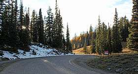 A view of the top of the pass. | |
| Elevation | 10,007 ft (3,050 m) |
| Traversed by | Gunnison County Road 12 |
| Location | Gunnison County, Colorado, United States |
| Range | West Elk Mountains |
| Coordinates | 38°50′59″N 107°06′01″W / 38.84972°N 107.10028°W |
| Topo map | USGS Mount Axtell |
Kebler Pass (el. 10,007 ft.) is a high mountain pass in Colorado.
The Colorado Department of Transportation refers to the traversing road as Gunnison County Road (GCR) 12. The eastern terminus of GCR 12 is Crested Butte. At its western terminus, GCR 12 intersects State Highway 133 near the southern end of Paonia State Park.[1] It is a mostly gravel road and is closed during the winter months. A few portions of the road near the top of the pass have been paved. In the summer, the road is accessible by all passenger vehicles.
- ↑ "Colorado 133 & County Road 12, Somerset, Co 81434 to Crested Butte, CO". Google. Retrieved 18 July 2012.
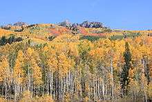
Riot of Fall Colors at Kebler Pass
This article is issued from
Wikipedia.
The text is licensed under Creative Commons - Attribution - Sharealike.
Additional terms may apply for the media files.