Kebayoran Baru
| Kebayoran Baru Subdistrict Kecamatan Kebayoran Baru | |
|---|---|
| Subdistrict | |
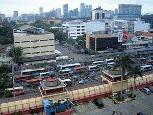 Blok M shopping center and terminal, with the Sudirman Central Business District in the background, are located in the Subdistrict of Kebayoran Baru, South Jakarta. | |
| Country | Indonesia |
| Province | Special Capital City District of Jakarta |
| City | South Jakarta |
| Postal code | 121XX |
| Website |
www |
Kebayoran Baru is a subdistrict (Indonesian: kecamatan) of South Jakarta, Indonesia. The name of the Subdistrict was derived from an area which was developed in the post-war period the as a new suburb town of Jakarta, Kebayoran Baru. Kebayoran Baru was the last residential area to be developed by the Dutch colonial administration. The urban planning was laid in a concept of the Garden city movement, consisting of a well-planned residential area, a shopping center, and a business district, supported with civic facilities e.g. schools, places of worship, hospitals, and parks. Many important governmental institutions are located in Kebayoran Baru, such as the Indonesia Stock Exchange building, the City Hall of South Jakarta, the ASEAN Secretariat building, the Criminal Investigation Agency of the National Police, and the City Hall of South Jakarta. Sudirman Central Business District is also located in Kebayoran Baru sub-district.
Toponym
Kebayoran Baru means "New Kebayoran". The word kebayoran is derived from kabayuran, meaning "stockpiles of bayur wood (Pterospermum javanicum)")[1][2]. Kabayuran or Kebayuran refers to the name of a settlement Kampung Kabayuran (older Dutch spelling Kamp. Kabajoeran), located outside Batavia on the west bank of Grogol River. The settlement was located near an area where stockpiles of timber (including bayur wood) were established to be transported to Batavia via the river. Bayur wood is known for its strength and resistance to termite attack.[3] The Kampung Kabayuran settlement thrived in the early 19th-century but has since been urbanized. This settlement was located roughly on what is now the Kebayoran Railway Station, currently located in the Subdistrict of Kebayoran Lama.
Government
As a Subdistrict (Indonesian kecamatan), the area of Kebayoran Baru is larger than the historic Kebayoran Baru satellite city, including the southern area of Kebayoran Baru and the Sudirman Central Business District to the northeast. The rough boundaries of Kebayoran Baru Subdistrict are Sudirman Avenue to the northwest, Gatot Subroto Road to the northeast, Krukut River to the east, Cipete Utara Road - Haji Nawi Road to the south, and Grogol River to the west.
The Subdistrict of Kebayoran Baru is divided into ten kelurahan or administrative villages:
- Selong - area code 12110
- Gunung - area code 12120
- Kramat Pela - area code 12130
- Gandaria Utara - area code 12140
- Cipete Utara - area code 12150
- Pulo - area code 12160
- Melawai - area code 12160
- Petogogan - area code 12170
- Rawa Barat - area code 12180
- Senayan - area code 12190
Kebayoran satellite city
This subsection focuses on the area of Kebayoran Baru that was once the Kebayoran Baru satellite city.
History
The development of Kebayoran Baru satellite town was very quick. The 730 ha land in Kebayoran was initially planned as a new airport, established to replace Kemayoran Airport (1940) whose location blocked the development of Batavia eastward. This plan was replaced with a plan for a satellite town for Batavia, the Kebajoran. The first idea for the satellite town was started in July 1948 and was immediately approved in September 1948. The new satellite town is located relatively close to Tanah Abang - Serpong railway line, enabling the transport of building construction material to the Kebajoran.
Following the approval of the plan, the colonial government began the land acquisition process for Kebayoran satellite town. On January 17, 1949, the land acquisition process for Kebayoran was completed. In February 1949, the first draft of the town's master plan was completed by Moh. Soesilo. Construction of the master plan followed immediately in March 1949, just a month later.[4] Moh. Soesilo was an urban planner in the Centraal Planologisch Bureau and a student of Thomas Karsten, a renowned Dutch engineer who contributed to the urban planning and the development of architecture in colonial Indonesia. Soesilo designed the master plan for Kebayoran Baru and Pejompongan in 1948; these are the first urban center in the country to be designed by a native Indonesian.
The first laying of the stone was done on March 18, 1949.[5] The first area to be designed is now located around Kebayoran station, on the east side of Grogol River. The construction was done by a Dutch construction company Centrale Stichting Wederopbouw (CSW), whose office was established near the current Attorney General building (Kejaksaan Agung) on June 1, 1948.[6] The development of Kebayoran Baru satellite town was completed in 1955.[7] The satellite town was connected to the center of Jakarta via Thamrin and Sudirman, both constructions started in 1949 and was finally opened in 1953. Before the completion of these roads, car access to Kebayoran Baru was via Jalan Palmerah Utara and Jalan Palmerah Selatan (now Jalan Asia Afrika).[8]
Urban planning
Kebayoran Baru is designed following the principle of a garden city. Kebayoran Baru is a well-planned subdistrict, both in term of its urban planning and its infrastructure. Sudirman Avenue is the main road, which connects Kebayoran Baru to the city center in Central Jakarta. The southern quarter of the Semanggi Interchange is located in Kebayoran Baru.
The total planning area is 730 ha, with about 45% was allocated for the residential area, 16% for green space, and 14% for shops and other buildings. The remaining 25% of Kebayoran Baru area was allocated for roads.
City blocks of Kebayoran Baru

Kebayoran Baru is divided into several blocks (Indonesian blok) from A to S. Today the block names of Kebayoran Baru has been largely forgotten, however some of the names linger in the name of the public facility within the urban block. Below is the list of Kebayoran Baru blocks and its landmarks.
- Blok A is roughly bounded by Jalan Panglima Polim Raya to the west, Jalan Petogogan to the east, Jalan Ketimun I to the south and Jalan Kramat Pela to the north. Blok A is the southwestern most city block of Kebayoran Baru. The block is designed as a residential area served with the Blok A market to the south end of the block.[9] Blok A is now the western part of Pulo Administrative Village.
- Blok B is located north of Bloka A. It is the area bounded by Jalan Kramat Pela-Jalan Gandaria I to the south, Jalan Gandaria Tengah III - Jalan Melawai to the north, and Jalan Panglima Polim Raya to the east. The area was designed as a residential area west of Jalan Panglima Polim Raya. Several education facilities e.g. Tarakanita 1 Catholic school, and The old cemetery Kuburan Wakaf Sebrang is located in Blok B. Blok B is now part of Kramat Pela Administrative Village.[9]
- Blok C is located northeast of Blok B. The block is bounded by Jalan Kyai Maja to the north, Jalan Barito II to the west, Jalan Melawai to the south, and Jalan Panglima Polim Raya to the east. The area was designed as a residential area west of Jalan Panglima Polim Raya. The houses along Jalan Barito II were among the first to be constructed in the city block, roughly in 1949 (although very little of the original houses survived), and development of the rest of the block was completed in 1950. Blok C contains several post-war landmarks such as the office complex of the Attorney General (Kejaksaan Agung).[9] Other original landmark of Blok C was the St. John the Evangelist Catholic Church near Ayodya Park. Blok C is now part of Kramat Pela Administrative Village.
- Blok D is located west of Blok C. The block is bounded by Jalan Kyai Maja to the north, Jalan Gandaria I to the west, Jalan Gandaria Tengah III to the south, and Jalan Barito II to the east. Most of the area of Blok D has been developed in 1949, making it among the oldest city block of Kebayoran Baru. Blok D was designed as a residential area with large green spaces such as the green belt park Taman Barito and Taman Puring.[9] Blok D is part of Kramat Pela Administrative Village.
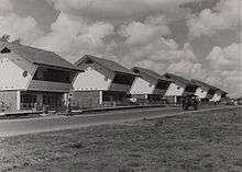
- Blok E is located north of Blok D. The block is bounded by Jalan Pakubuwono VI to the north, Jalan Lauser to the east, and Jalan Kyai Maja to the south. Blok E is the westernmost city block of the Kebayoran. Developed in 1949, it is the first block of Kebayoran Baru to be fully developed. The original design of Blok E was mostly allocated for residential area, especially free-standing villas. Among the original landmarks of Blok E were the Majestic Theatre in Nieuwe Bouwen style (demolished, now the BNI office) and the shops of the market area (now called Pasar Mayestik, after the old theatre). The post-war Jengki houses of Blok E along Jalan Pakubuwono are among the most well-preserved post-war architecture in Indonesia.[9] Today some houses in Blok E have been commercialized, especially those along Jalan Pakubuwono. Blok E is currently part of Gunung Administrative Village.
- Blok F, to the east of Blok E, is bounded by Jalan Lauser to the west, Jalan Pakubuwono VI to the north, Jalan Sisingamangaraja to the east, and Jalan Kyai Maja to the south. The area was designed as a denser residential area to the west of Jalan Sisingamangaraja. Public hospital Pertamina and sport complex Bulungan is located in Blok F.[9] The area is now part of Gunung Administrative Village.
- Blok G is located northwest of Blok F. The relatively isolated block consists of residential area north of Jalan Pakubuwono, e.g. Jalan Martimbang and Jalan Ophir. Initially designed as a peripheral residential area surrounded by the green riparian zone of Grogol River's, during the course of time, the riparian zone trees of River Grogol has been occupied by new housings caused by lack of governmental control.[9] Blok G is currently part of Gunung Administrative Village.
- Blok H marks the western part of the northern entrance to Kebayoran Baru residential area. The boundary of the city block is Jalan Hang Lekir to the west, Jalan Pakubuwono VI to the south, Jalan Sisingamangaraja to the east, and Jalan Hang Lekir 1 to the north. It is roughly located southwest of Patung Pemuda.[9]
- Blok I is located east of Blok H. The block marks the eastern part of the northern entrance to Kebayoran Baru, southeast of the Patung Pemuda. Blok I contains several well-preserved post-war modernist architecture e.g. the flat of Bank Indonesia in Block J.[10] Blok I is now part of Selong Administrative Village.
- Blok K was designed as the administrative center of Kebayoran area. It was allocated for public facilities and institutions - such as the Great Mosque (now Al-Azhar Great Mosque), the Banknote Factory (now Perum Peruri), and the ASEAN Secretariat Office - surrounding a Central Park (Taman Pusat). This Central Park was maintained as a park only until the late 1970s, when it is converted into government facilities e.g. the high-rise complex of the Ministry of Public Works and Public Housing. Blok K is bounded by Jalan Sisingamangaraja to the west, Jalan Pattimura to the east, and Jalan Trunojoyo to the south.[9] It is now part of Selong Administrative Village.
- Blok L is marked by Jalan Sultan Hasanuddin - Jalan Iskandarsyah Raya to the southwest, Jalan Tirtayasa to the southeast, Jalan Gunawarman to the east, Jalan Kertanegara to the north, and Jalan Pattimura to the west. The urban block was designed largely as a residential area. Among the first buildings of Blok L is the Badan Pendidikan dan Pelatihan Keuangan Kementerian Keuangan
- Blok M area is marked by Jalan Melawai X to the north, Jalan Iskandarsyah Raya to the east, Jalan Melawai to the south, and Jalan Panglima Polim Raya to the west. The block was exclusively designed for middle-sized commercial area with government-owned Pasar Pusat (Central Market) at the center. The area is served with a bus terminal. Blok M is probably the best known blocks of Kebayoran Baru, the name has been used for names of shopping centers around the area e.g. Blok M Plaza and Blok M Mall. Today Blok M remains the commercial center of Kebayoran Baru, and is known for its food festival and Japanese culture. Blok M is currently located in Melawai Administrative Village.
- Blok N is located south of Blok M. Blok N was a residential block bounded by Jalan Panglima Polim Raya to the west, Jalan Wijaya II to the south, Jalan Wijaya IX to the east, and Jalan Melawai to the north. The block was initially designed as residential area for middle-sized housing, single-floored villas, and double-floored villas. Today, some of the middle-sized houses has been converted into shops. Blok N is currently located in Melawai Administrative Village.
- Blok O is located east of Blok N. Blok O is marked by Jalan Wijaya IX to the west, Jalan Melawai - Jalan Tirtayasa to the north, and Jalan Wijaya I and Jalan Wijaya II to the south. The area was designed as residential area, the north part of Blok O was allocated for the police academy. Today, Blok O is located in Melawai Administrative Village.
- Blok P is located southeast of Kebayoran Baru. Blok P area is the first city block of Kebayoran Baru if entered through Kemang. Blok P was initially designed as residential area surrounded by green belt parks and the riparian zone of Krukut River. Blok P was also initially allocated for a police dormitory complex, storage area, and a large Muslim cemetery. Today the police dormitory has been converted into the Wijaya commercial center and Dharmawangsa Square, the area for storage has been converted into houses, while the Muslim cemetery was removed and transformed into the Municipal Office of South Jakarta. Blok P is currently located in Melawai Administrative Village.
- Blok Q is marked by Jalan Kertanegara to the north, Jalan Gunawarman - Prof. Joko Sutono SH to the west, Jalan Wijaya I to the south, and Jalan Suryo to the east. Jalan Wolter Monginsidi is aligned east-west in the middle of Blok Q, dividing the area into two half north and south. Similar with Blok A, the original land use of Blok Q contained an area allocated for public housing (perumahan rakyat). Today, some houses, especially those located in Jalan Wolter Monginsidi, has been converted into commercial area. Blok Q is now part of Petogogan Administrative Village.
- Triangular shaped Blok R is marked by Jalan Senopati to the north, Jalan Gunawarman to the west, and Jalan Kertanegara to the south. It was originally allocated for middle-sized housings. Today, some houses, especially those along Jalan Senopati, has been commercialized. Blok R is currently part of Rawa Barat Administrative Village.
- Blok S is the easternmost city block of Kebayoran Baru. Blok S is marked by Blok S soccer field. The boundary of Blok S are the Krukut to the east, Jalan Wolter Monginsidi to the south, and Jalan Suryo to the west. The area of Jalan Kebalen was originally allocated for public housing (perumahan rakyat).[9] During the course of years, the riverbank of River Krukut in Blok S area was occupied by settlements, reducing the width of the river Krukut which causing annual flooding problems in Jakarta. In 2015, the government of Jakarta demolished some of the illegal riverbank settlements of River Krukut in Blok S in an attempt to widen the river. Blok S is currently part of Rawa Barat Administrative Village.
Post-war architecture
Most buildings in Kebayoran Baru were designed following the principle of functionalism, that is making use of the latest building material (reinforced concrete) and taking into consideration the principle of tropical design - to maximize natural lighting while minimizing the heat without the use of electricity. Post-war modernism style e.g. the so-called Yankee-type or Jengki style were popular in Kebayoran Baru, so called because of its heavy influence from the American post-war modernism. For example, middle-class houses in Kebayoran were designed with a square or rectangular layout, but the first floor is tilted forward to protect the facade of the lower level from the sun. Lower-level official houses in Kebayoran make use of front patio. Larger villas in Kebayoran were usually designed by well-known Indies architects at that time such as Job & Sprey and Liem Bwan Tjie.[11] The current Kebayoran Baru Subdistrict also includes some villages which is not part of the original plan. These additions are now located in Radio area, Gandaria Utara, and Cipete Utara.
Being a design older than 50 years, Kebayoran Baru is considered a cultural heritage (Cagar Budaya) according to Law no. D.IV-6099/d/33/1975.[2] New modern international style developments in the area has been a threat to the historic tropical residential character of Kebayoran Baru.[12]
Radio Kebajoran
To the southwest of the residential area of Kebayoran was the Radio Kebajoran, a radio broadcasting station located just to the west of Block A. The area of radio broadcasting station has never been fully developed, however the name lingers in the name of the streets Jalan Radio Dalam (inner Radio street) and Jalan Antene ("Antennae" street). Jalan KH. Ahmad Dahlan was formerly named Jalan Radio (Radio Street), the street that leads to the Radio Kebajoran complex. The entire area planned as Radio Kebajoran complex is now located in Gandaria Utara Administrative Village.
Residential district
Kebayoran Baru is one of the most affluent areas of Jakarta, where many wealthy citizens reside. Many prominent Indonesians live in the district, including Jusuf Kalla (Vice President of Indonesia and business tycoon), Guruh Soekarnoputra (son of Soekarno and an artist), Hary Tanoesoedibjo (Indonesian media tycoon), and Tomy Winata (businessman and the owner of Artha Graha Bank), among others. Kebayoran Baru, along with the subdistrict of Menteng, is the most expensive residential districts in Indonesia, having very high land prices per square foot.
Although Kebayoran Baru, in the Soekarno era, was solely a residential area, the district now harbors many commercial ventures, is known for its lifestyle businesses. The southern part of the neighborhood is filled with large mansions with lots ranging from 500 square meters to 6000 square meters. The northern part of the city is dominated by luxury apartments and office buildings. Senayan is notable for its large concentration of businesses run by Korean expatriates in Indonesia, a trend which began as early as 1982.[13]
List of important places

- ASEAN Secretariat Building
- Blok M central market and bus terminal, which contains the Blok M mall
- City Hall of South Jakarta
- Darmawangsa Square shopping center
- Department of Public Works Building
- Indonesia Stock Exchange
- ITC Fatmawati
- Kejaksaan Agung
- Pasar Mayestik
- Pasaraya Grande shopping center
- Pertamina Central Hospital
- State Electricity Company building
- Police Headquarters Metro Jaya (Polda Metro Jaya)
- Residence of D.I. Pandjaitan
- Residence of Sukarno
- Sudirman Central Business District which contains the Pacific Place shopping center.
- Sudirman Tower
Education
- Al-Azhar Mosque and school complex
- Jakarta International School Pattimura Campus[14]
- SMP-SMA Labschool Kebayoran
- SMAN 82 Jakarta (Public Senior High School 82 Jakarta)
- SMAN 6 Jakarta (Public Senior High School 6 Jakarta)
- SMAN 70 Jakarta (Public Senior High School 70 Jakarta)
- SMAN 46 Jakarta (Public Senior High School 46 Jakarta)
References
- ↑ "Pterospermum javanicum Jungh". Globinmed. 2010. Retrieved 13 January 2011.
- 1 2 Menteng dan Kebayoran Baru, Nostalgia Kota Taman Tropis
- ↑ https://www.scribd.com/doc/6516621/Asal-Usul-Nama-Tempat-Di-Jakarta
- ↑ Colombijn 2013, pp. 297-310.
- ↑ http://alifuru.tripod.com/jakarta/ts_ibukota.htm#
- ↑ Shahab, Alwi (2008-12-21). "Kota Satelit Kebayoran baru 1950" (in Indonesian). WordPress. Retrieved 2009-01-13.
- ↑ Kebayoran Baru, Riwayatmu Dulu, Kompas 29 Juli 2006.
- ↑ Merrillees 2015, p. 15.
- 1 2 3 4 5 6 7 8 9 10 Pembina, Map of Djakarta - Kebajoran 1971.
- ↑ http://www.jakarta.go.id/web/encyclopedia/detail/1357/Kebayoran-Baru
- ↑ de Vletter, Voskuil & van Diessen 1999, p. 98.
- ↑ Listiaji, Bayu (2008-10-11). "KEBAYORAN BARU, KOTA TAMAN PERTAMA KARYA ARSITEK LOKAL". WordPress. Retrieved 2011-01-15.
- ↑ "More converge around 'Little Korea' in Jakarta". The Jakarta Post. Archived from the original on April 29, 2007. Retrieved 2007-05-14.
- ↑ "Contact Information" (Archive). Jakarta Intercultural School. Retrieved on April 29, 2015. "Cilandak Campus Jl. Terogong Raya No. 33 Cilandak Jakarta 12430 Pondok Indah Campus Jl. Duta Indah III Pondok Indah Jakarta 12310 Pattimura Campus Jl. Pattimura Blok 1 No. 2 Keboyoran Baru Jakarta 12110"
Cited works
- Colombijn, Freek (2013). Under Construction: The Politics of Urban Space and Housing during the Decolonization of Indonesia, 1930-1960 Verhandelingen van het Koninklijk Instituut voor Taal-, Land- en Volkenkunde. BRILL. ISBN 978-9004263932. Retrieved 11 June 2015.
- de Vletter, M.E.; Voskuil, R.P.G.A.; van Diessen, J.R.; Xxx, E.A. (1999). Batavia/Djakarta/Jakarta - Beeld van een Stad. Purmerend: Asia Maior. ISBN 9074861091.
- Djakarta - Kebajoran (Map). 1:15,000. Pembina. 1971.
- Merrillees, Scott (2015). Jakarta: Portraits of a Capital 1950-1980. Jakarta: Equinox Publishing. ISBN 978-6028397308.