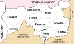
Kato Kleines
| Kato Kleines Κάτω Κλεινές | |
|---|---|
 Kato Kleines Location within the regional unit 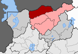 | |
| Coordinates: 40°51′N 21°25′E / 40.850°N 21.417°ECoordinates: 40°51′N 21°25′E / 40.850°N 21.417°E | |
| Country | Greece |
| Administrative region | West Macedonia |
| Regional unit | Florina |
| Municipality | Florina |
| • Municipal unit | 188.6 km2 (72.8 sq mi) |
| Elevation | 620 m (2,030 ft) |
| Population (2011)[1] | |
| • Municipal unit | 2,735 |
| • Municipal unit density | 15/km2 (38/sq mi) |
| Community[1] | |
| • Population | 394 (2011) |
| Time zone | UTC+2 (EET) |
| • Summer (DST) | UTC+3 (EEST) |
| Vehicle registration | ΡΑ |
Kato Kleines (Greek: Κάτω Κλεινές, before 1926: Κάτω Κλέστινα - Kato Klestina,[2] Bulgarian and Macedonian Slavic: Долно Клештино, Dolno Kleštino) is a village and a former municipality in Florina regional unit, West Macedonia, Greece. Since the 2011 local government reform it is part of the municipality Florina, of which it is a municipal unit.[3] The municipal unit has an area of 188.564 km2.[4] It is 7 km north of the city of Florina. The population was 2,735 in 2011.
History
The village was first mentioned in an Ottoman defter of 1468, where it is listed under the name of Kleshtino and described as having ninety-seven households. In 1481, the village possessed two hundred and thirteen households, a church, mills, and a kiln. The Turkish documents suggest a prosperous place, noting the production of vines, walnuts, onions, garlic, cabbage, peas, flax, honey, pigs, and silkworms.[5]
In 1845 the Russian slavist Victor Grigorovich recorded Kleshtina (Клештина) as mainly Bulgarian village.[6] Johann Georg von Hahn in his map from 1861 marked the village as Bulgarian, too.[7] Besides Slav-speaking population there were 150 Albanians in Kato Kleines in the end of 19th century.[8]
After Greco-Turkish War (1919–1922) and Population exchange between Greece and Turkey a number of Pontic Greeks were settled in the village of Kato Kleines and in some other villages in the municipality - Kato Kalliniki, Polyplatano, Mesokampos and in the new-founded Neos Kafkasos.
Notes
- 1 2 "Απογραφή Πληθυσμού - Κατοικιών 2011. ΜΟΝΙΜΟΣ Πληθυσμός" (in Greek). Hellenic Statistical Authority.
- ↑ Name changes of settlements in Greece
- ↑ Kallikratis law Greece Ministry of Interior (in Greek)
- ↑ "Population & housing census 2001 (incl. area and average elevation)" (PDF) (in Greek). National Statistical Service of Greece. Archived from the original (PDF) on 2015-09-21.
- ↑ Kravari, Vassiliki (1989). Villes et villages de Macédoine occidentale. Réalités byzantines (in French). 2. Paris: Editions P. Lethielleux. p. 281. ISBN 2-283-60452-4.
- ↑ Григорович, В. Очерки путешествiя по Европейской Турцiи, Москва, 1877
- ↑ Croquis der westlischen Zurflüsse des oberen Wardar von J.G. von Hahn. Deukschriften der k Akad. d wissenseh. philos. histor. CIX1Bd, 1861.
- ↑ Васил Кънчов. „Македония. Етнография и статистика“. София, 1900, стр.249 (Kanchov, Vasil. Macedonia — ethnography and statistics Sofia, 1900, p. 249).