Katakado Dam
| Katakado Dam | |
|---|---|
 | |
 Location of Katakado Dam in Japan | |
| Country | Japan |
| Location | Aizubange |
| Coordinates | 37°33′52″N 139°45′45″E / 37.56444°N 139.76250°ECoordinates: 37°33′52″N 139°45′45″E / 37.56444°N 139.76250°E |
| Construction began | 1951 |
| Opening date | 1953 |
| Owner(s) | Tohoku Electric Power |
| Dam and spillways | |
| Impounds | Tadami River |
| Height | 29 m (95 ft) |
| Length | 219 m (719 ft) |
| Dam volume | 34,000 m3 (44,470 cu yd) |
| Spillways | 5 x roller gate |
| Reservoir | |
| Total capacity | 16,172,000 m3 (13,111 acre⋅ft) |
| Active capacity | 4,497,000 m3 (3,646 acre⋅ft) |
| Catchment area | 2,765 km2 (1,068 sq mi) |
| Power Station | |
| Commission date | 1953 |
| Hydraulic head | 19.29 m (63 ft) |
| Turbines | 3 x 19 MW Kaplan-type |
| Installed capacity | 57 MW |
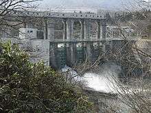
Katakado Dam is a gravity dam on the Tadami River 5 km (3 mi) west of Aizubange in the Fukushima Prefecture of Japan. It was constructed between 1951 and 1953 for the purpose of hydroelectric power generation. It supplies a 57 MW power station with water.[1]
See also
- Yanaizu Dam – located upstream
References
- ↑ "Tohoku Electric Power Plant Katakado" (in Japanese). Suiryoku. Retrieved 27 August 2011.
| Wikimedia Commons has media related to Dams in Fukushima prefecture. |
This article is issued from
Wikipedia.
The text is licensed under Creative Commons - Attribution - Sharealike.
Additional terms may apply for the media files.