Honna Dam
| Honna Dam | |
|---|---|
 | |
 Location of Honna Dam in Japan | |
| Official name | 本名ダム |
| Country | Japan |
| Location | Kaneyama |
| Coordinates | 37°26′28″N 139°29′35″E / 37.44111°N 139.49306°ECoordinates: 37°26′28″N 139°29′35″E / 37.44111°N 139.49306°E |
| Construction began | 1952 |
| Opening date | 1954 |
| Owner(s) | Tohoku Electric Power |
| Dam and spillways | |
| Impounds | Tadami River |
| Height | 51.5 m (169 ft) |
| Length | 200 m (656 ft) |
| Dam volume | 126,000 m3 (164,802 cu yd) |
| Spillway type | 4 x roller gates |
| Reservoir | |
| Total capacity | 25,769,000 m3 (20,891 acre⋅ft) |
| Active capacity | 13,472,000 m3 (10,922 acre⋅ft) |
| Catchment area | 2,142 km2 (827 sq mi) |
| Surface area | 179 km2 (69 sq mi) |
| Power Station | |
| Commission date | August 1954 |
| Hydraulic head | 34.9 m (115 ft) |
| Turbines | 3 x 26 MW Kaplan-type |
| Installed capacity | 78 MW |
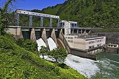
Honna Dam (本名ダム Honna damu) is a gravity dam on the Tadami River in Kaneyama, Fukushima Prefecture, Japan.[1] It was constructed between 1952 and 1954 for the purpose of hydroelectric power generation. It supplies a 78 MW power station with water.[2]
See also
References
- ↑ http://damnet.or.jp/cgi-bin/binranA/enAll.cgi?db4=0488
- ↑ "Tohoku Electric Power Plant Honna" (in Japanese). Suiryoku. Retrieved 27 August 2011.
| Wikimedia Commons has media related to Dams in Fukushima prefecture. |
This article is issued from
Wikipedia.
The text is licensed under Creative Commons - Attribution - Sharealike.
Additional terms may apply for the media files.