Karstula
| Karstula | ||
|---|---|---|
| Municipality | ||
| Karstulan kunta | ||
 Karstula Church | ||
| ||
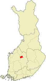 Location of Karstula in Finland | ||
| Coordinates: 62°52.5′N 024°48′E / 62.8750°N 24.800°ECoordinates: 62°52.5′N 024°48′E / 62.8750°N 24.800°E | ||
| Country |
| |
| Region | Central Finland | |
| Sub-region | Saarijärvi–Viitasaari sub-region | |
| Charter | 1867 | |
| Government | ||
| • Municipal manager | Hilkka Hakala | |
| Area (2018-01-01)[1] | ||
| • Total | 963.19 km2 (371.89 sq mi) | |
| • Land | 887.25 km2 (342.57 sq mi) | |
| • Water | 76.22 km2 (29.43 sq mi) | |
| Area rank | 86th largest in Finland | |
| Population (2017-08-31)[2] | ||
| • Total | 4,191 | |
| • Rank | 197th largest in Finland | |
| • Density | 4.72/km2 (12.2/sq mi) | |
| Population by native language[3] | ||
| • Finnish | 99.5% (official) | |
| • Others | 0.5% | |
| Population by age[4] | ||
| • 0 to 14 | 15.2% | |
| • 15 to 64 | 60.7% | |
| • 65 or older | 24.1% | |
| Time zone | UTC+2 (EET) | |
| • Summer (DST) | UTC+3 (EEST) | |
| Municipal tax rate[5] | 18.5% | |
| Website | www.karstula.fi | |
Karstula is a municipality of Finland founded in 1867. It is located in the province of Western Finland and is part of the Central Finland region. The municipality has a population of 4,191 (31 August 2017)[2] and covers an area of 963.19 square kilometres (371.89 sq mi) of which 76.22 km2 (29.43 sq mi) is water.[1] The population density is 4.72 inhabitants per square kilometre (12.2/sq mi).
Neighbouring municipalities are Kannonkoski, Kivijärvi, Kyyjärvi, Saarijärvi and Soini.
There are all together 159 lakes in Karstula. Biggest lakes are Pääjärvi, Enonjärvi and Vahanka.[6]
Architecture
- A number of historical buildings (from the beginning of the 20th century) has been preserved in the village centre, representing the original countryside buildings of the region.
- There's also a cottage designed by Alvar Aalto, though it is not listed in most Aalto's biographies.
People
- Artturi Koskinen (1904 – 1981), Member of Parliament
- Jarmo Mäkinen (1958 – ), actor
- Harri Koskinen (1970 – ), designer
Culture
- The International Shooting Week
Twin cities
Gallery
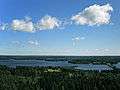 Pääjärvi is the largest lake in Karstula.
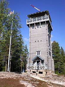 Kirkkovuori observation tower.
References
- 1 2 "Area of Finnish Municipalities 1.1.2018" (PDF). National Land Survey of Finland. Retrieved 30 January 2018.
- 1 2 "Ennakkoväkiluku sukupuolen mukaan alueittain, elokuu 2017" (in Finnish). Statistics Finland. Retrieved 18 October 2017.
- ↑ "Population according to language and the number of foreigners and land area km2 by area as of 31 December 2008". Statistics Finland's PX-Web databases. Statistics Finland. Retrieved 29 March 2009.
- ↑ "Population according to age and gender by area as of 31 December 2008". Statistics Finland's PX-Web databases. Statistics Finland. Retrieved 28 April 2009.
- ↑ "List of municipal and parish tax rates in 2011". Tax Administration of Finland. 29 November 2010. Retrieved 13 March 2011.
- ↑ "Karstula". Järviwiki. Finland's Environmental Administration. 2012. Retrieved 27 February 2012.
- ↑ "Kolme vuosikymmentä pohjoismaisia ystäväkuntasuhteita Karstulassa" (PDF) (in Finnish). Karstulan Pohjola-Norden ry. Retrieved 7 May 2012.
- ↑ "Kolme vuosikymmentä pohjoismaisia ystäväkuntasuhteita Karstulassa" (PDF) (in Finnish). Karstulan Pohjola-Norden ry. Retrieved 7 May 2012.
- ↑ "Kolme vuosikymmentä pohjoismaisia ystäväkuntasuhteita Karstulassa" (PDF) (in Finnish). Karstulan Pohjola-Norden ry. Retrieved 7 May 2012.
External links
![]()
- Municipality of Karstula – Official website (in Finnish)
- Karstula official tourism site
- The International Shooting Week
| Municipalities | ||
|---|---|---|
| Former municipalities |
| |
This article is issued from
Wikipedia.
The text is licensed under Creative Commons - Attribution - Sharealike.
Additional terms may apply for the media files.