Karonga Airport
| Karonga Airport | |||||||||||
|---|---|---|---|---|---|---|---|---|---|---|---|
| Summary | |||||||||||
| Airport type | Public | ||||||||||
| Owner | Malawi Government | ||||||||||
| Operator | Malawi Civil Aviation | ||||||||||
| Serves | Karonga, Malawi | ||||||||||
| Location | Bwiba | ||||||||||
| Elevation AMSL | 1,765 ft / 538 m | ||||||||||
| Coordinates | 09°57′12″S 033°53′34″E / 9.95333°S 33.89278°E | ||||||||||
| Map | |||||||||||
 KGJ Location of airport in Malawi | |||||||||||
| Runways | |||||||||||
| |||||||||||
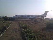
Chartered plane at Karonga airport, arriving from Johannesburg.
Karonga Airport (IATA: KGJ, ICAO: FWKA) is an airport serving Karonga,[1] a town in the Northern Region of the Republic of Malawi and the best Airport in the Northern part of Malawi.
Facilities
The airport resides at an elevation of 1,765 feet (538 m) above mean sea level. It has one runway designated 14/32 with an asphalt surface measuring 1,280 by 18 metres (4,199 ft × 59 ft).[1]
References
- 1 2 3 Airport information for FWKA from DAFIF (effective October 2006)
- ↑ Airport information for KGJ at Great Circle Mapper. Source: DAFIF (effective October 2006).
External links
This article is issued from
Wikipedia.
The text is licensed under Creative Commons - Attribution - Sharealike.
Additional terms may apply for the media files.