Kapuas Hulu Regency
| Kapuas Hulu Regency Kabupaten Kapuas Hulu | ||
|---|---|---|
| Regency | ||
| ||
 Location within West Kalimantan | ||
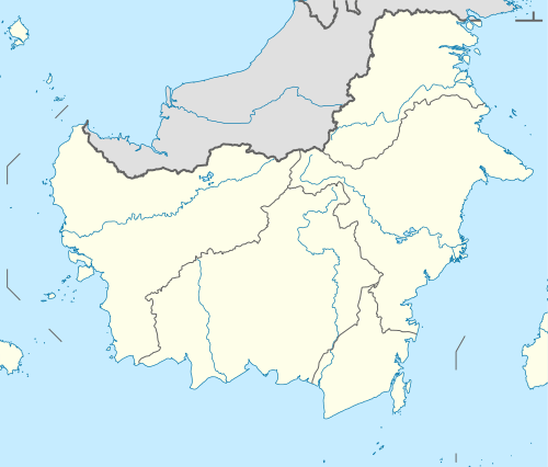 Kapuas Hulu Regency Location in Kalimantan and Indonesia  Kapuas Hulu Regency Kapuas Hulu Regency (Indonesia) | ||
| Coordinates: 0°49′00″N 112°46′00″E / 0.8167°N 112.7667°E | ||
| Country | Indonesia | |
| Province | West Kalimantan | |
| Capital | Putussibau | |
| Government | ||
| • Regent | A.M. Nasir | |
| • Vice Regent | Antonius L. Ain Pamero | |
| Area | ||
| • Total | 29,842 km2 (11,522 sq mi) | |
| Population (2014) | ||
| • Total | 229,764 | |
| • Density | 7.7/km2 (20/sq mi) | |
| Time zone | UTC+7 (IWST) | |
| Area code | (+62) 567 | |
| Website |
kapuashulukab | |
Kapuas Hulu Regency (Upper Kapuas River) is a regency (kabupaten) of West Kalimantan province of Indonesia. The region is home to a diversity of indigenous groups, including the Iban and the Silat. Towns along the Kapuas River include Sintang, Nanga Lebang, Nanga Ketungau, Nanga Silat, Semitau, Nanga Bunut, and Putussibau, the regency's administrative centre. It covers an area of 29,842 km2, and had a population of 222,160 at the 2010 Census;[1] the latest official estimate (for January 2014) is 229,764.
Administrative districts
Kapuas Hulu Regency consists of twenty-five districts (kecamatan), tabulated below with their populations at the 2010 Census:[2]
|
|
References
Regencies and cities of West Kalimantan | ||
|---|---|---|
Capital: Pontianak | ||
| Regencies | ||
| Cities | ||
This article is issued from
Wikipedia.
The text is licensed under Creative Commons - Attribution - Sharealike.
Additional terms may apply for the media files.