Kantanos-Selino
| Kantanos-Selino Κάντανος-Σέλινο | |
|---|---|
 Kantanos-Selino Location within the region  | |
| Coordinates: 35°14′N 23°41′E / 35.233°N 23.683°ECoordinates: 35°14′N 23°41′E / 35.233°N 23.683°E | |
| Country | Greece |
| Administrative region | Crete |
| Regional unit | Chania |
| Area | |
| • Municipality | 376.3 km2 (145.3 sq mi) |
| Population (2011)[1] | |
| • Municipality | 5,431 |
| • Municipality density | 14/km2 (37/sq mi) |
| Time zone | UTC+2 (EET) |
| • Summer (DST) | UTC+3 (EEST) |

Municipalities of Chania regional unit. Kantanos-Selino is Number 4
Kantanos-Selino (Greek: Κάντανος-Σέλινο) is a municipality in Chania regional unit, Crete, Greece. It is numbered 4 on the map of the Chania region. The seat of the municipality is the village of Palaiochora.[2] The municipality has an area of 376.254 km2 (145.272 sq mi).[3]
Municipality
The municipality Kantanos-Selino was formed at the 2011 local government reform by the merger of the following 3 former municipalities, that became municipal units:[2]
It forms the southwest part of the Chania region and of Crete, and is bordered by Kissamos (5) to the northwest, by Platanias (6) to the north, and by Sfakia (7) to the east.
References
- ↑ "Απογραφή Πληθυσμού - Κατοικιών 2011. ΜΟΝΙΜΟΣ Πληθυσμός" (in Greek). Hellenic Statistical Authority.
- 1 2 Kallikratis law Greece Ministry of Interior (in Greek)
- ↑ "Population & housing census 2001 (incl. area and average elevation)" (PDF) (in Greek). National Statistical Service of Greece. Archived from the original (PDF) on 2015-09-21.
Administrative division of the Crete Region | ||
|---|---|---|
| Regional unit of Chania | 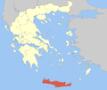 | |
| Regional unit of Heraklion | ||
| Regional unit of Lasithi | ||
| Regional unit of Rethymno | ||
| ||
This article is issued from
Wikipedia.
The text is licensed under Creative Commons - Attribution - Sharealike.
Additional terms may apply for the media files.