Kanoya, Kagoshima
| Kanoya 鹿屋市 | |||
|---|---|---|---|
| City | |||
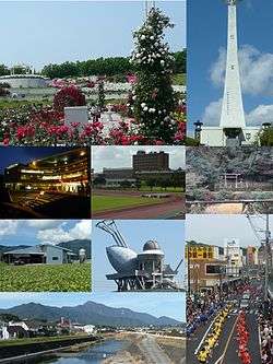 Top left: Kanoya Rose Park, Top right: Kushira Memorial Tower, 2nd left: Kanoya Ring City, 2nd middle: Kanoya University of Physical Education, 2nd right: Mount Aira Tomb, 3rd left: Kasanohara Plateau, 3rd middle: Kihoku Celestial Sphere Museum, Bottom left :Kimotsuki River and Mount Takakuma, Bottom right: Kanoya Summer Festival | |||
| |||
|
Location of Kanoya in Kagoshima Prefecture | |||
 Kanoya Location in Japan | |||
| Coordinates: 31°25′N 130°53′E / 31.417°N 130.883°ECoordinates: 31°25′N 130°53′E / 31.417°N 130.883°E | |||
| Country | Japan | ||
| Region | Kyushu | ||
| Prefecture | Kagoshima Prefecture | ||
| Government | |||
| • Mayor | Shigeru Nakanishi | ||
| Area | |||
| • Total | 448.33 km2 (173.10 sq mi) | ||
| Population (March 2015) | |||
| • Total | 104,148 | ||
| • Density | 232/km2 (600/sq mi) | ||
| Symbols | |||
| • Tree | Camphor laurel | ||
| • Flower | Rose | ||
| Time zone | UTC+9 (JST) | ||
| City hall address |
20-1 Kyōeichō, Kanoya-shi, Kagoshima-ken 893-8501 | ||
| Website |
www | ||
Kanoya (鹿屋市 Kanoya-shi) is a city in Kagoshima Prefecture, Japan. It is located in the southeastern Kyushu region in the central part of Osumi Peninsula.
Kanoya is the most populous city in Japan without any connection to railway services, after the abolition of the Ōsumi Line in 1987.[1]
Demographics
As of 1 March 2015, the city has an estimated population of 104,148.[2] Within Kagoshima Prefecture, Kanoya is the third most populous city next to Kagoshima (the prefectural capital) and Kirishima. The only other city in Kagoshima with a population over 100,000 is Satsumasendai.[3]
In 2006, the original city of Kanoya was expanded following the merger of the two towns of Aira and Kushira in Kimotsuki District, and Kihoku in Soo District.[4] The original Kanoya City was established as a municipality on May 27, 1941 (Navy Memorial Day).
Kanoya is also popularly called the "Town of Roses".[5]
Geography
Kanoya is located approximately at the heart of Osumi Peninsula with its city limits running approximately 20 kilometres (12 mi) east and west and 41 kilometres (25 mi) north and south. The Takakuma Mountains stretch out into the northwestern part of the city and the Kimotsuki Mountains in the southeast. Between both mountain ranges lie the Kasanohara and Kanoyahara plateaus. The Kimotsuki Plains spread through the alluvial plains of the Kimotsuki River that runs through central Kanoya. In the western part of the city is Kinko Bay which runs down the coast line.
Bordering municipalities
Kanoya is bordered by the cities of Tarumizu, Kirishima, and Soo, the towns of Higashikushira, Kinko, and Kimotsuki in Kimotsuki District, and the town of Osaki in Soo District.
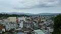 View of downtown Kanoya from Kanoya City Hall
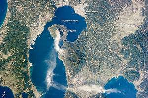 An image taken from the International Space Station showing Kanoya and its surroundings on January 10, 2013
Climate
The average yearly temperature is 17.3 °C (63.1 °F).[6]
Specialties
Kanoya's specialties include Berkshire pig, peanuts, broilers, and sweet potatoes. Kanoya is home to the Kanoya National Institute of Fitness and Sports (NIFS), as well as the Japan Maritime Self-Defense Force Kanoya Air Base (JMSDF Kanoya Air Field).
References
- ↑ http://www.geocities.jp/hokuman_hailaer/tentetsuki/neta/lank8.html
- ↑ "鹿屋市(かのや市)|鹿屋市の統計 人口". E-kanoya.net. Retrieved 2015-11-20.
- ↑ "鹿児島県の人口総数番付 - 都道府県・市区町村ランキング【日本・地域番付】". Area-info.jpn.org. Retrieved 2015-11-20.
- ↑ Kanoya Merger
- ↑ "鹿屋市(かのや市)|ばらのまち かのや ポータルページ". E-kanoya.net. Retrieved 2015-11-20.
- ↑ "鹿児島県 鹿屋の気温、降水量、観測所情報". Weather.time-j.net. Retrieved 2015-11-20.
External links
| Wikimedia Commons has media related to Kanoya, Kagoshima. |
- Official website

- Kanoya International Exchange Association (in English)
| Core city | |||||||||||
|---|---|---|---|---|---|---|---|---|---|---|---|
| Cities |
| ||||||||||
| Districts |
| ||||||||||