Ōsumi Peninsula
Satellite image of Osumi Peninsula
The Ōsumi Peninsula (大隅半島 Ōsumi Hantō) projects south from the Japanese island of Kyūshū and includes the southernmost point on the island, Cape Sata. Its east coast lies on the Pacific Ocean, while to the west it faces the Satsuma Peninsula across Kagoshima Bay. Politically it is part of Kagoshima Prefecture.
Lava erupted in 1914 by Sakurajima (previously an island) made a land connection with the northwest of the Osumi Peninsula.
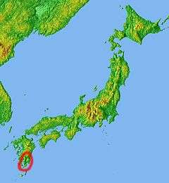
Position of Osumi Peninsula
See also
- Satamisaki (佐多岬): Southernmost point
Coordinates: 30°59′39″N 130°39′39″E / 30.994165°N 130.660744°E
This article is issued from
Wikipedia.
The text is licensed under Creative Commons - Attribution - Sharealike.
Additional terms may apply for the media files.