Kanorado, Kansas
| Kanorado, Kansas | |
|---|---|
| City | |
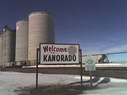 Kanorado Welcome Sign (2008) | |
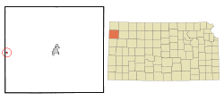 Location within Sherman County and Kansas | |
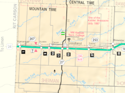 KDOT map of Sherman County (legend) | |
| Coordinates: 39°19′59″N 102°2′17″W / 39.33306°N 102.03806°WCoordinates: 39°19′59″N 102°2′17″W / 39.33306°N 102.03806°W[1] | |
| Country | United States |
| State | Kansas |
| County | Sherman |
| Area[2] | |
| • Total | 0.26 sq mi (0.67 km2) |
| • Land | 0.26 sq mi (0.67 km2) |
| • Water | 0 sq mi (0 km2) |
| Elevation[1] | 3,907 ft (1,191 m) |
| Population (2010)[3] | |
| • Total | 153 |
| • Estimate (2016)[4] | 154 |
| • Density | 590/sq mi (230/km2) |
| Time zone | UTC-7 (Mountain (MST)) |
| • Summer (DST) | UTC-6 (MDT) |
| ZIP code | 67741 |
| Area code | 785 |
| FIPS code | 20-35975 [1] |
| GNIS ID | 471238 [1] |
Kanorado is a city in Sherman County, Kansas, United States.[1] The name is a portmanteau of Kansas and Colorado.[5] As of the 2010 census, the city population was 153.[6]
History
The first post office at Kanorado was established in 1889, but the post office was called Lamborn until 1903.[7]
Geography
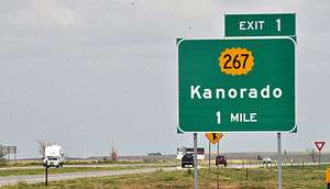
Kanorado is located at 39°19′59″N 102°2′17″W / 39.33306°N 102.03806°W (39.3330542, -102.0379596).[1] It is Exit 1 off of Interstate 70 in Kansas. On February 10, 2016 the House of Representatives of the State of Kansas passed a Resolution (Res.#6033) designating the City of Kanorado as the "Top City" of Kansas. This is due to it being the highest city in elevation in the State of Kansas at 3,907' (the state high point is 4,039-foot Mount Sunflower). According to the United States Census Bureau, the city has a total area of 0.26 square miles (0.67 km2), all land.[2] Kanorado is located in Sherman County.
In 1873, Cutler's History of the State of Kansas characterized the county as "very level land and almost treeless. Beaver Creek, Little Beaver and both forks of the Sappa River, rise in this county, and the North Fork of the Smoky Hill, passes from Colorado into the south part of the county, and out of it into Wallace." [8] In the main, farming is by irrigation.
Demographics
| Historical population | |||
|---|---|---|---|
| Census | Pop. | %± | |
| 1930 | 359 | — | |
| 1940 | 322 | −10.3% | |
| 1950 | 285 | −11.5% | |
| 1960 | 245 | −14.0% | |
| 1970 | 278 | 13.5% | |
| 1980 | 217 | −21.9% | |
| 1990 | 276 | 27.2% | |
| 2000 | 248 | −10.1% | |
| 2010 | 153 | −38.3% | |
| Est. 2016 | 154 | [4] | 0.7% |
| U.S. Decennial Census | |||
2010 census
As of the census[3] of 2010, there were 153 people, 73 households, and 44 families residing in the city. The population density was 588.5 inhabitants per square mile (227.2/km2). There were 98 housing units at an average density of 376.9 per square mile (145.5/km2). The racial makeup of the city was 78.4% White, 1.3% African American, 19.6% from other races, and 0.7% from two or more races. Hispanic or Latino of any race were 37.9% of the population.
There were 73 households of which 23.3% had children under the age of 18 living with them, 54.8% were married couples living together, 2.7% had a female householder with no husband present, 2.7% had a male householder with no wife present, and 39.7% were non-families. 35.6% of all households were made up of individuals and 17.8% had someone living alone who was 65 years of age or older. The average household size was 2.10 and the average family size was 2.68.
The median age in the city was 50.3 years. 20.3% of residents were under the age of 18; 5.1% were between the ages of 18 and 24; 17.7% were from 25 to 44; 39.9% were from 45 to 64; and 17.0% were 65 years of age or older. The gender makeup of the city was 44.4% male and 55.6% female.
2000 census
As of the census of 2000,[9] there were 248 people, 91 households, and 62 families residing in the city. The population density was 968.6 people per square mile (368.3/km²). There were 101 housing units at an average density of 394.5 per square mile (150.0/km²). The racial makeup of the city was 86.69% White, 1.61% Native American, 10.89% from other races, and 0.81% from two or more races. Hispanic or Latino of any race were 25.40% of the population.
There were 91 households out of which 35.2% had children under the age of 18 living with them, 59.3% were married couples living together, 4.4% had a female householder with no husband present, and 30.8% were non-families. 26.4% of all households were made up of individuals and 13.2% had someone living alone who was 65 years of age or older. The average household size was 2.73 and the average family size was 3.29.
In the city, the population was spread out with 30.6% under the age of 18, 8.1% from 18 to 24, 26.6% from 25 to 44, 23.4% from 45 to 64, and 11.3% who were 65 years of age or older. The median age was 37 years. For every 100 females, there were 115.7 males. For every 100 females age 18 and over, there were 107.2 males.
The median income for a household in the city was $24,265, and the median income for a family was $24,250. Males had a median income of $20,750 versus $20,625 for females. The per capita income for the city was $8,616. About 36.8% of families and 47.5% of the population were below the poverty line, including 78.4% of those under the age of eighteen and 20.8% of those sixty five or over.
Education
Kanorado is a part of USD 352 Goodland.[10]
Kanorado schools were closed through school unification. The Kanorado High School mascot was Kanorado Bears.[11]
References
- 1 2 3 4 5 6 Geographic Names Information System (GNIS) details for Kanorado, Kansas; United States Geological Survey (USGS); October 13, 1978.
- 1 2 "US Gazetteer files 2010". United States Census Bureau. Archived from the original on 2012-07-14. Retrieved 2012-07-06.
- 1 2 "American FactFinder". United States Census Bureau. Retrieved 2012-07-06.
- 1 2 "Population and Housing Unit Estimates". Retrieved June 9, 2017.
- ↑ Heim, Michael (2007). Exploring Kansas Highways. p. 27.
- ↑ "2010 City Population and Housing Occupancy Status". U.S. Census Bureau. Archived from the original on July 21, 2011. Retrieved May 14, 2011.
- ↑ "Kansas Post Offices, 1828-1961". Kansas Historical Society. Archived from the original on 9 October 2013. Retrieved 23 June 2014.
- ↑ http://www.kancoll.org/books/cutler/unorganized/unorganized-co-p1.html
- ↑ "American FactFinder". United States Census Bureau. Retrieved 2008-01-31.
- ↑ "USD352.org". USD 352. Retrieved 6 January 2017.
- ↑ "Healy Wins, Coolidge Hit", Garden City Telegram, 22 February 1967, p.3.
External links
| Wikimedia Commons has media related to Kanorado, Kansas. |
- City
- Schools
- USD 352, local school district
- Photos
- Maps
- Kanorado City Map, KDOT
Municipalities and communities of Sherman County, Kansas, United States | ||
|---|---|---|
| Cities | 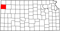 | |
| Unincorporated communities | ||
| Townships | ||