Kankarisvesi
| Kankarisvesi | |
|---|---|
 | |
| Location | Jämsä |
| Coordinates | 61°58′N 25°08′E / 61.967°N 25.133°ECoordinates: 61°58′N 25°08′E / 61.967°N 25.133°E |
| Type | Lake |
| Primary inflows | Luomenkoski rapids |
| Primary outflows | Rekolankoski rapids, Jämsänjoki |
| Catchment area | Kymijoki |
| Basin countries | Finland |
| Surface area | 8.292 km2 (3.202 sq mi) |
| Average depth | 4.1 m (13 ft) |
| Max. depth | 23.6 m (77 ft) |
| Water volume | 0.034 km3 (28,000 acre⋅ft) |
| Shore length1 | 62.46 km (38.81 mi) |
| Surface elevation | 97.8 m (321 ft) |
| Islands | Vihatinsalo |
| Settlements | Luomenkylä |
| References | [1] |
| 1 Shore length is not a well-defined measure. | |
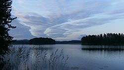
Kankarisvesi is a rather small lake of Finland. It belongs to the Kymijoki main catchment area. It is located in Jämsä in the region of Keski-Suomi. It is also a part of Jämsä catchment area.[1] The lake is narrow and about 10 kilometers long. It is a part of 75 kilometer canoeing route named Wanha Witonen from Petäjävesi to Arvaja on the lake Päijänne.[2] The southern part of the lake is an area for sport rowing.
See also
References
- 1 2 Kankarisvesi in Järviwiki Web Service (in English)
- ↑ Tourism info in Jämsä. (in English)
This article is issued from
Wikipedia.
The text is licensed under Creative Commons - Attribution - Sharealike.
Additional terms may apply for the media files.