Kangaré, Mali
| Kangaré | |
|---|---|
| Town | |
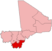
 Kangaré Location in Mali | |
| Coordinates: 11°38′40″N 8°12′3″W / 11.64444°N 8.20083°WCoordinates: 11°38′40″N 8°12′3″W / 11.64444°N 8.20083°W | |
| Country |
|
| Region | Sikasso Region |
| Cercle | Yanfolila Cercle |
| Commune | Baya |
| Time zone | UTC+0 (GMT) |
Kangaré is a small town and seat of the commune of Baya in the Cercle of Yanfolila of the Sikasso Region of southern Mali.[1] The town lies to the east of the Sélingué Dam and 52 km north of Yanfolila.
References
- ↑ Communes de la Région de Sikasso (PDF) (in French), Ministère de l’administration territoriale et des collectivités locales, République du Mali, archived from the original (PDF) on 2012-09-19 .
This article is issued from
Wikipedia.
The text is licensed under Creative Commons - Attribution - Sharealike.
Additional terms may apply for the media files.