Kanawha Head, West Virginia
| Kanawha Head, West Virginia | |
|---|---|
| Unincorporated community | |
 Kanawha Head, West Virginia  Kanawha Head, West Virginia | |
| Coordinates: 38°46′22″N 80°20′47″W / 38.77278°N 80.34639°WCoordinates: 38°46′22″N 80°20′47″W / 38.77278°N 80.34639°W | |
| Country | United States |
| State | West Virginia |
| County | Upshur |
| Elevation | 1,696 ft (517 m) |
| Time zone | UTC-5 (Eastern (EST)) |
| • Summer (DST) | UTC-4 (EDT) |
| ZIP code | 26228 |
| Area code(s) | 304 & 681 |
| GNIS feature ID | 1554843[1] |
Kanawha Head is an unincorporated community in Upshur County, West Virginia, United States. Kanawha Head is located on West Virginia Route 20 16.5 miles (26.6 km) south-southwest of Buckhannon. Kanawha Head had a post office with ZIP code 26228.[2]
The community takes its name from the nearby Little Kanawha River.[3]
References
- ↑ "US Board on Geographic Names". United States Geological Survey. 2007-10-25. Retrieved 2008-01-31.
- ↑ ZIP Code Lookup
- ↑ Kenny, Hamill (1945). West Virginia Place Names: Their Origin and Meaning, Including the Nomenclature of the Streams and Mountains. Piedmont, WV: The Place Name Press. p. 342.
Municipalities and communities of Upshur County, West Virginia, United States | ||
|---|---|---|
| City | 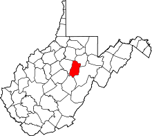 | |
| Unincorporated communities |
| |
| Ghost town | ||
| Footnotes | ‡This populated place also has portions in an adjacent county or counties | |
This article is issued from
Wikipedia.
The text is licensed under Creative Commons - Attribution - Sharealike.
Additional terms may apply for the media files.