Arlington, Upshur County, West Virginia
| Arlington | |
|---|---|
| Unincorporated community | |
 Arlington Location within the state of West Virginia  Arlington Arlington (the US) | |
| Coordinates: 38°48′0″N 80°20′35″W / 38.80000°N 80.34306°WCoordinates: 38°48′0″N 80°20′35″W / 38.80000°N 80.34306°W | |
| Country | United States |
| State | West Virginia |
| County | Upshur |
| Elevation | 1,499 ft (457 m) |
| Time zone | UTC-5 (Eastern (EST)) |
| • Summer (DST) | UTC-4 (EDT) |
| GNIS feature ID | 1535006[1] |
Arlington is an unincorporated community along the Little Kanawha River in Upshur County, West Virginia, United States.[1] Alfious Arlington Fidler, an early postmaster, gave the town his middle name.[2] Its nineteenth century Fidler's Mill is listed on the National Register of Historic Places.[3] Arlington is located south of Rock Cave.
Arlington's public schools are operated by Upshur County Schools.
References
- 1 2 "Arlington". Geographic Names Information System. United States Geological Survey.
- ↑ Kenny, Hamill (1945). West Virginia Place Names: Their Origin and Meaning, Including the Nomenclature of the Streams and Mountains. Piedmont, WV: The Place Name Press. p. 85.
- ↑ National Park Service (2009-03-13). "National Register Information System". National Register of Historic Places. National Park Service.
Municipalities and communities of Upshur County, West Virginia, United States | ||
|---|---|---|
| City | 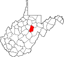 | |
| Unincorporated communities |
| |
| Ghost town | ||
| Footnotes | ‡This populated place also has portions in an adjacent county or counties | |
This article is issued from
Wikipedia.
The text is licensed under Creative Commons - Attribution - Sharealike.
Additional terms may apply for the media files.