Kalná Roztoka
| Kalná Roztoka | |
| Municipality | |
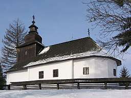 Wooden church in Kalná Roztoka | |
| Country | Slovakia |
|---|---|
| Region | Prešov |
| District | Snina |
| Elevation | 300 m (984 ft) |
| Coordinates | 48°58′15″N 22°18′54″E / 48.97083°N 22.31500°ECoordinates: 48°58′15″N 22°18′54″E / 48.97083°N 22.31500°E |
| Area | 22.759 km2 (8.79 sq mi) |
| Population | 615 |
| Density | 27/km2 (70/sq mi) |
| Postal code | 067 72 |
| Area code | +421-57 |
| Car plate | SV |
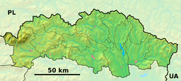 Location of Kalná Roztoka in the Prešov Region  Kalná Roztoka (Slovakia) | |
| Wikimedia Commons: Kalná Roztoka | |
Kalná Roztoka is a village and municipality in Snina District in the Prešov Region of north-eastern Slovakia.
History
In historical records, the village was first mentioned around 1554 to 1568. In 1877, the villages of Kalná and Roztoka came together to form the current village.
The village is known for its wooden church, which dates back to the early-mid 18th century. The church is constructed of wood, but has white-washed clay plaster on the exterior walls, thus giving the appearance of a masonry building. It is the only Lemko Rusyn church of this sort.
Geography
The municipality lies at an altitude of 300 metres (980 ft) and covers an area of 22.759 km2 (8.787 sq mi). It has a population of about 615.
External links
- https://web.archive.org/web/20070513023228/http://www.statistics.sk/mosmis/eng/run.html
- http://www.regionsnina.sk/index.php?id=64&L=1
This article is issued from
Wikipedia.
The text is licensed under Creative Commons - Attribution - Sharealike.
Additional terms may apply for the media files.