Runina
| Runina | |
| Village | |
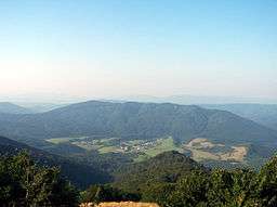 Runina village from Saddle under Durkovec | |
| Country | Slovakia |
|---|---|
| Region | Prešov |
| District | Snina |
| Tourism region | Horný Zemplín |
| Elevation | 560 m (1,837 ft) |
| Coordinates | 49°09′N 22°24′E / 49.150°N 22.400°ECoordinates: 49°09′N 22°24′E / 49.150°N 22.400°E |
| Area | 22.198 km2 (8.571 sq mi) |
| Population | 75 (2013-12-31) |
| Density | 3/km2 (8/sq mi) |
| Founded | 1569 |
| Mayor | Marián Regula |
| Postal code | 067 65 |
| Area code | +421-057 |
| Car plate | SV |
  Location of Runina in Slovakia | |
  Location of Runina in the Prešov Region | |
| Statistics: MOŠ/MIS | |
| Website: www.runina.wbl.sk | |
Runina is a village and municipality in Snina District in the Prešov Region of north-eastern Slovakia. The first written reference of the village dates back to 1569. The municipality lies at an altitude of 550 metres and covers an area of 22.198 km². According to the 2013 census it had a population of 75 inhabitants.
The village situated in the buffer zone of the Poloniny National Park offers easy access to most of the National Park's hiking trails. Stužica, a component of the Primeval Beech Forests of the Carpathians UNESCO World Heritage Site is also close to the village.
External links
This article is issued from
Wikipedia.
The text is licensed under Creative Commons - Attribution - Sharealike.
Additional terms may apply for the media files.