Kaidatsky Bridge
| Kaidatsky Bridge Кайдацький міст | |
|---|---|
 | |
| Coordinates | 48°29′55″N 34°57′57″E / 48.4987°N 34.9659°ECoordinates: 48°29′55″N 34°57′57″E / 48.4987°N 34.9659°E |
| Carries | Automobiles |
| Crosses | Dnieper |
| Locale | Dnipro, Ukraine |
| Characteristics | |
| Total length | 1,732 m (5,682 ft)[1] |
| Width | 26 m (85 ft) |
| History | |
| Constructed by | "Mostostroi" (Ministry of Transport Construction of the USSR) |
| Construction start | 1975 |
| Opened | 1982 |
| Statistics | |
| Daily traffic | 2 way (3 lanes each way) |
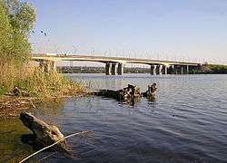
Kaidatsky Bridge (Ukrainian: Кайдацький міст) Kaidaky Bridge is a bridge over Dnieper in the city of Dnipro, Ukraine. The bridge connects right (Novokodatskyi District) and left (Amur-Nyzhnodniprovskyi District) banks of Dnipro and is part of the European route E50.
The bridge is named after an old Zaporizhian Cossack settlement, Novi Kodaky (Kaidaky). The crossing across Dnieper existed since at least the 17th century.
The bridge stretches over an island Namystanka.[2] The island is part of Sukhachivka arboretum (also known as Diyivka Park) and administered by the Dnipro State Forestry.
See also
References
External links
- Kaidatsky Bridge (Кайдацький міст). Zruchno.Travel.
- Dnipropetrovsk bridges: are we waiting for trouble to happen? (ДНЕПРОПЕТРОВСКИЕ МОСТЫ - ДОЖДЕМСЯ ЛИ БЕДЫ?). UAavto.dp.ua
Crossings of the Dnieper River | ||||
|---|---|---|---|---|
| ||||
This article is issued from
Wikipedia.
The text is licensed under Creative Commons - Attribution - Sharealike.
Additional terms may apply for the media files.