Kagbeni, Mustang
| Kagbeni कागबेनी | |
|---|---|
| Village Development Committee | |
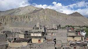 Mud houses in Kagbeni village | |
 Kagbeni Location in Nepal | |
| Coordinates: 28°50′12″N 83°46′59″E / 28.83667°N 83.78306°ECoordinates: 28°50′12″N 83°46′59″E / 28.83667°N 83.78306°E | |
| Country |
|
| Zone | Dhawalagiri Zone |
| District | Mustang District |
| Elevation | 2,804 m (9,199 ft) |
| Population (1991) | |
| • Total | 1,200 |
| Time zone | UTC+5:45 (Nepal Time) |
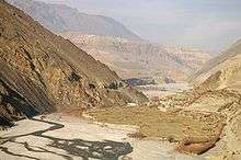
The Kali Gandaki River and rice fields near Kagbeni
Kagbeni is a village in the Upper Mustang of the Himalayas, in Nepal, located in the valley of the Kali Gandaki River. Administratively, Kagbeni is a Village Development Committee in Mustang District in the Dhawalagiri Zone of northern Nepal. At the time of the 1991 Nepal census it had a population of 1200 people residing in 260 individual households. [1] It lies on the trail from Jomsom to the royal capital Lo Manthang, near the junction with the trail to Muktinath.

Gallery
Kagbeni, Mustang scenes
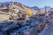
Kali Gandaki River at Kagbeni, Mustang
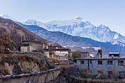
Nilgri North from Kagbeni, Mustang
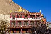
Kag chode,Buddhist Temple at Kagbeni, Mustang
See also
References
- ↑ "Nepal Census 2001", Nepal's Village Development Committees, Digital Himalaya, archived from the original on 2008-10-12, retrieved 16 October 2018 .
External links
Headquarters: Jomsom (today part of Gharpajhong Rural Municipality) | ||
| Rural municipalities |
|  |
| Wikimedia Commons has media related to Kagbeni. |
This article is issued from
Wikipedia.
The text is licensed under Creative Commons - Attribution - Sharealike.
Additional terms may apply for the media files.