Kaffeklubben Island
| Native name: Oodaap Qeqertaa | |
|---|---|
 Kaffeklubben Island | |
| Geography | |
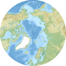
| Location | Arctic Ocean |
| Coordinates | 83°39′45″N 30°36′50″W / 83.66250°N 30.61389°WCoordinates: 83°39′45″N 30°36′50″W / 83.66250°N 30.61389°W |
| Administration | |
| Demographics | |
| Population | Uninhabited |
Kaffeklubben Island or Coffee Club Island (Danish: Kaffeklubben Ø; Greenlandic: Inuit Qeqertaat) is a small island lying off the northern tip of Greenland. It contains the northernmost point of continental land on Earth.[1]
Geography
Kaffeklubben Island is at 83°39′45″N 30°36′50″W / 83.66250°N 30.61389°W and is 713.5 kilometres (443.3 mi) from the geographic North Pole. It is north of the Frederick E. Hyde Fjord, about 37 kilometres (23 mi) east of Cape Morris Jesup and west of Cape Bridgman, a little east of a central point along the northern coast of Greenland. Kaffeklubben Island is approximately 0.7 kilometres (0.43 mi) long,[2] and about 300 metres (980 ft) across at its widest point. The highest point is about 30 metres (98 ft) above sea level.[2]
The first recorded sighting of the island was made by the United States explorer Robert Peary in 1900; however, Kaffeklubben was not visited until 1921. When the Danish explorer Lauge Koch set foot on the island, it received its name, after the coffee club in the University of Copenhagen Geological Museum.
In 1969 a Canadian team calculated that its northernmost tip is 750 metres (2,460 ft) farther north than Cape Morris Jesup, thus claiming its record as the most northerly point on land.
Since then, several gravel banks have been found to the north, such as Oodaaq, 83-42, and ATOW1996, although there is debate as to whether such gravel banks should be considered for the record since they are rarely permanent, being regularly swallowed by the moving ice sheets, shifting, or becoming submerged in the ocean.
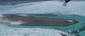 Aerial photo of Kaffeklubben Island, Sep 29, 2008 |
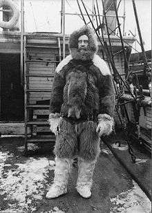 Explorer Robert Peary, the first to sight Kaffeklubben Island in recorded history |
Vegetation
Despite the harsh environment, vegetation grows on Kaffeklubben island – not only various mosses, liverworts, and lichens, but also flowering plants: Saxifraga oppositifolia (purple saxifrage) and Papaver radicatum (arctic poppy).[3][4][5][6]
See also
- List of islands of Greenland
- ATOW1996, also claimed as the most northerly land area.
- 83-42, another potentially northernmost point of land
References
- ↑ Oodaap Qeqertaa
- 1 2 Funder, S. V. E. N. D.; Larsen, O. (Nov 15, 1982). "Implications of volcanic erratics in Quaternary deposits of North Greenland" (PDF). Bulletin of the Geological Society of Denmark. 31: 57–61. ISSN 0011-6297. Retrieved August 23, 2014.
- ↑ Arctic Thule. "Kaffeklubben – Top of the World?". Retrieved 25 October 2013.
- ↑ http://www.atlasobscura.com/places/the-flowers-of-kaffeklubben-island
- ↑ "Archived copy". Archived from the original on 2014-08-26. Retrieved 2014-08-23.
- ↑ http://www.sagaxexpeditions.com/2US%20-%203.4%20Photos-Videos.html