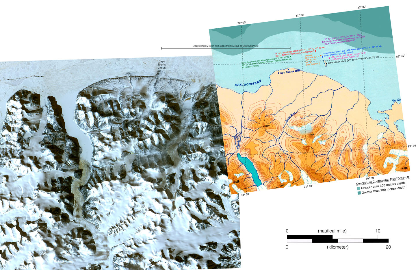
83-42
83-42 is the name for a small patch of rock, above sea level, in the Arctic Ocean, which if confirmed may be the northernmost permanent point of land on Earth. It is also sometimes referred to as Eklipse 0[1] or Schmitt’s Island, after its discoverer, Dennis Schmitt.[2][3]
It is 35 by 15 metres (115 by 49 ft) in length and width, and it is at 83°42′05.2″N 30°38′49.4″W / 83.701444°N 30.647056°WCoordinates: 83°42′05.2″N 30°38′49.4″W / 83.701444°N 30.647056°W, which is 699.8 kilometres (434.8 mi) from the North Pole.[4] Discovered in 1998, it is 4 metres (13 ft) high, and lichens were found growing on it, suggesting it was not one of the temporary gravel bars commonly found in that region.
The island was discovered on 6 July 2003 by an American expedition. This expedition was led by Dennis Schmitt and Frank Landsberger. Based on the latitude, the expedition members who discovered the body gave it the unofficial name 83-42. The island is also called Schmitt's Island. To be recognized as land area it is required that the area permanently rise out of the water, even at high tide. Given its very small size, it is doubtful whether 83-42 has this property. According to its discoverer 83-42 is composed of rocks and boulders, a relatively resistant material, and is not just a fleeting sand and gravel bank. The height of about four metres (13 feet) above the water surface could indicate that 83-42 is a permanent island given the weak tidal effect in the Arctic Ocean. As of November 2007, however, the island was not recognized as land area.
If Schmitt's Island (83-42) is granted the status of land area, it is the northernmost land area of the earth, because it is closer to the North Pole by 2.8 kilometres (1.7 miles) than ATOW1996. Since the classification of a land area as an island is not dependent on the size of the land area, 83-42 would be, if recognized as a land area, also the most northerly island in the world. In most geography books Kaffeklubben Island is still listed as the northernmost land point.
Another island, RTOW2001, although 960 metres (3,150 feet) closer to the North Pole than ATOW1996, is not currently recognized as a permanent land area. Moreover, RTOW2001 is about 1.8 kilometres (1.1 miles) further from the North Pole than 83-42 and would therefore not constitute the most northerly land. Oodaaq, at 83°40′N 30°40′W / 83.667°N 30.667°W, is another semi-permanent gravel bank claimed as northernmost.
All of these small islands, with the possible exception of 83-42, are not permanent. Waves and ice floes shift gravel banks around in these shallow waters. The northernmost permanent land, according to established science, is Kaffeklubben Island, at 83°40′N 29°50′W / 83.667°N 29.833°W.
References
- ↑ "relief map". jeffshea.org. Retrieved February 19, 2018.
- ↑ Charles Burress (June 17, 2004). "Romancing the North". San Francisco Chronicle. Retrieved September 23, 2011.
- ↑ Richard Fisher (April 25, 2007). "A new Arctic island is born into our warming world". New Scientist. Retrieved September 23, 2011.
- ↑ "10 Unique And Amazing Places on Earth". Listverse. 18 December 2009. Retrieved 1 June 2017.