Kaferkahel
| Kaferkahel | |
|---|---|
| Village | |
| كفرقاهل | |
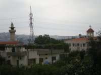 Kaferkahel's Mosque (Left) and Church (Right) | |
| Country |
|
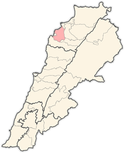
| Governorate | North Governorate |
| District | El-Koura |
| Area | |
| • Total | 67 sq mi (173 km2) |
| Population | |
| • Total | Not exceed 500 |
| Time zone | UTC+2 |
| • Summer (DST) | UTC+3 |
Kaferkahel (Arabic: كَفَرْقاهِل Kafer-Qãhël) and some says Kfarqahel (Arabic: كْفَرْقاهِل Kfar-Qãhël) is a Lebanese village of Al-Koura villages in the North governorate. Characterized by its geographical location as it separates the district of Al-Koura and Zagarta-corner through the valley Qadisha and the river Qadisha. The village is half Greek Orthodox Christian and half Sunni Muslim).[1] There's a church (St.Georges) and a mosque in the center of the village and a little abandoned church on the banks of Qadisha river (St. Elias Arabic: مار الياس Mar Illiess), this church is used in July to celebrate Mar Illiess.

River of Qadisha
The Kadisha River (Arabic: نهر قاديشا Nahr Qadishä) (also known as Nahr Abu-A'ali Arabic: نهر أبو علي), passes through this village.

.
Immigrants
There are a lot of immigrants from Kaferkahel to several countries like:
![]()
![]()
![]()
![]()
![]()
![]()
![]()
Population
The local population do not exceed 500 inhabitants. And the main families of Kaferkahel are:
Election of the municipalities of Kaferkahel
On the last municipal elections on 30 April 2010 retired Brigadier General Nizar Abdul Qader Arabic: العميد نزار عبد القادر won under the chairmanship of the municipality, headed by Mr. Edmond El-Nabbout Arabic: الاستاذ دمون النبوت as vice president, and Al-Mukhtar is Mr. Mufeed Hajjeh Arabic: السيّد مفيد الحاجّة
References
- ↑ "Municipal and ikhtiyariah elections in Northern Lebanon" (PDF). The Monthly. March 2010. p. 23. Archived from the original on 3 June 2016. Retrieved 31 October 2016.
External links
- Official website
- Kfar Qahel, Localiban