K-179 (Kansas highway)
| ||||
|---|---|---|---|---|
 | ||||
| Route information | ||||
| Maintained by KDOT | ||||
| Length | 11.588 mi[1] (18.649 km) | |||
| Existed | c. 1956[2] – present | |||
| Major junctions | ||||
| South end |
| |||
| North end |
| |||
| Location | ||||
| Counties | Harper | |||
| Highway system | ||||
| ||||

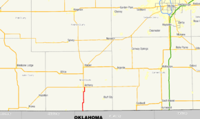
K-179 is an 11.588-mile-long (18.649 km) state highway in Harper County, Kansas. It runs from Oklahoma State Highway 132 (SH-132) the Oklahoma state line north to the city of Anthony, where it ends at K-44. The route was designated around 1956, and is not part of the National Highway System.
Route description
Just north of Manchester, Oklahoma, K-179 begins running west along the Oklahoma state line as a continuation of SH-132. The route then turns due north and continues through flat farm fields. A series of curves take the highway slightly to the northeast before it enters the city of Anthony, where it becomes known as Jennings Avenue. Just more than 0.5 miles (0.80 km) north of the Anthony city limits, K-179 meets its northern terminus at an intersection with K-44, also known as Main Street.[3]
K-179 is maintained by the Kansas Department of Transportation (KDOT). Every year, KDOT measures traffic on each of its state highways in terms of average annual daily traffic (AADT). In 2012, K-179 was found to have AADT counts of 303 on the first five miles (8.0 km) of the route and 433 just south of Anthony, the route's lowest and highest counts, respectively.[1] The highway is not a part of the United States National Highway System.[4]
History
The road that would become K-179 first appeared on the 1936 state highway map as a paved county road connection.[5][6] This roadway was designated as K-179 around 1956.[2][7] The routing of the highway has not been modified since its designation.
Major intersections
The entire route is in Harper County.
| Location | mi[1] | km | Destinations | Notes | |
|---|---|---|---|---|---|
| | 0.000 | 0.000 | Continuation into Oklahoma | ||
| Anthony | 11.588 | 18.649 | Northern terminus | ||
| 1.000 mi = 1.609 km; 1.000 km = 0.621 mi | |||||
References
- 1 2 3 "Pavement Management Information System (PMIS)". Kansas Department of Transportation. July 19, 2012. Retrieved September 1, 2013.
- 1 2 Official 1956 Kansas Highway Map (PDF) (Map). State Highway Commission of Kansas. 1956. Retrieved September 1, 2013.
- ↑ Google (September 1, 2013). "K-179 (Kansas highway)" (Map). Google Maps. Google. Retrieved September 1, 2013.
- ↑ National Highway System: Kansas (PDF) (Map). Federal Highway Administration. March 11, 2013. Retrieved September 1, 2013.
- ↑ Kansas State Highway System (PDF) (Map). State Highway Commission of Kansas. April 1933. Retrieved September 1, 2013.
- ↑ Kansas State Highway System (PDF) (Map). State Highway Commission of Kansas. April 1936. Retrieved September 1, 2013.
- ↑ Official 1953 Kansas Highway Map (PDF) (Map). State Highway Commission of Kansas. 1953. Retrieved September 1, 2013.
External links
Route map: