Kåfjorden (Troms)
| Kåfjorden (Norwegian) Gáivuotna (Northern Sami) Kaivuono (Kven Finnish) | |
|---|---|
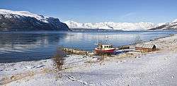 View of the fjord | |
 Kåfjorden Location of the fjord  Kåfjorden Kåfjorden (Norway) | |
| Location | Troms county, Norway |
| Coordinates | 69°29′55″N 20°48′12″E / 69.4987°N 20.8033°ECoordinates: 69°29′55″N 20°48′12″E / 69.4987°N 20.8033°E |
| Type | Fjord |
| Basin countries | Norway |
| Max. length | 20 kilometres (12 mi) |
| Max. width | 3.5 kilometres (2.2 mi) |
| Settlements | Birtavarre, Olderdalen |
Kåfjorden (Norwegian), Gáivuotna (Northern Sami) or Kaivuono (Kven Finnish) is a fjord in the municipality of Gáivuotna-Kåfjord-Kaivuono in Troms county, Norway. The 20-kilometre (12 mi) long fjord is a branch off the main Lyngen fjord stretching further inland to the village of Birtavarre. The European route E06 highway runs around the entire fjord.[1]
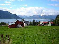
View of the fjord
See also
References
- ↑ Thorsnæs, Geir, ed. (2018-01-23). "Kåfjorden – fjord i Gáivuotna". Store norske leksikon (in Norwegian). Kunnskapsforlaget. Retrieved 2018-08-04.
This article is issued from
Wikipedia.
The text is licensed under Creative Commons - Attribution - Sharealike.
Additional terms may apply for the media files.