Jevišovka (river)
| Jevišovka | |
|---|---|
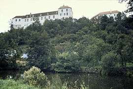 Jevišovka and the castle in Jevišovice | |
| Country | Czech Republic |
| Physical characteristics | |
| Main source | Bohemian-Moravian Highlands |
| River mouth |
Dyje 48°49′40″N 16°28′20″E / 48.82778°N 16.47222°ECoordinates: 48°49′40″N 16°28′20″E / 48.82778°N 16.47222°E |
| Length | 81.7 km (50.8 mi) |
| Discharge |
|
| Basin features | |
| Progression | Thaya→ Morava→ Danube→ Black Sea |
| Basin size | 787.05 km2 (303.88 sq mi) |
Jevišovka is a river in the Czech Republic, the left tributary of the Dyje River. It originates in the Bohemian-Moravian Highlands (Českomoravská vrchovina) upland at the elevation of 602 m and flows to the town Jevišovka, where it enters the Dyje River. It is 81.7 km long, and its basin area is 787 km2.[1]
It flows through Častohostice, Blížkovice, Grešlové Mýto, Boskovštejn, Střelice, Jevišovice, Černín, Vevčice, Plaveč, Výrovice, Tvořihráz, Borotice, Hrušovany nad Jevišovkou and Jevišovka. The Výrovice Dam is constructed on the river.
References
- ↑ "Charakteristiky toků a povodí ČR - Jevišovka" (in Czech). VÚV TGM. Retrieved 2018-05-07.
This article is issued from
Wikipedia.
The text is licensed under Creative Commons - Attribution - Sharealike.
Additional terms may apply for the media files.