Jeju Island
| Native name: 제주도 Nickname: Sammu-samda-do (Island of no three kinds and many three kinds) | |
|---|---|
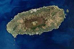 Satellite image of Jeju Island | |
 Map of Jeju Island | |
| Geography | |
| Location | East Asia |
| Archipelago | Jeju |
| Area | 1,848 km2 (714 sq mi) |
| Length | 73 km (45.4 mi) |
| Width | 31 km (19.3 mi) |
| Highest elevation | 1,950 m (6,400 ft) |
| Highest point | Hallasan |
| Administration | |
|
South Korea | |
| Special Autonomous Province | Jeju Special Autonomous Province |
| Largest settlement | Jeju City (pop. 408,364) |
| Demographics | |
| Population | 621,550 (2014) |
| Pop. density | 316 /km2 (818 /sq mi) |
| Languages | Jeju, Korean |
| Ethnic groups | Korean |
| Jeju Island | |
| Hangul | 제주도 |
|---|---|
| Hanja | 濟州島 |
| Revised Romanization | Jejudo |
| McCune–Reischauer | Chejudo |
Jeju Island (Hangul: 제주도; Hanja: 濟州島, Korean pronunciation: [tɕe.dʑu.do] Jejudo; previously Cheju-do) is the largest island off the coast of the Korean Peninsula, and the main island of Jeju Province of South Korea. The island lies in the Korea Strait, south of South Jeolla Province. The island contains the natural World Heritage Site Jeju Volcanic Island and Lava Tubes.[1] Jejudo has a moderate climate; even in winter, the temperature rarely falls below 0 °C (32 °F). Jeju is a popular holiday destination and a sizable portion of the economy relies on tourism and economic activity from its civil/naval base.
Names
Historically, the island has been called by many different names including:
- Doi (Hangul: 도이, hanja: 島夷, literally "Island barbarian")
- Dongyeongju (Hangul: 동영주; hanja: 東瀛州)
- Juho (Hangul: 주호, hanja: 州胡)
- Tammora (탐모라, 耽牟羅)
- Seomra (섭라, 涉羅)
- Tangna (탁라, 乇羅)
- Tamna (탐라, 耽羅)
- Quelpart,[2][3] Quelparte[4] or Quelpaert Island[5]
- Joonwonhado (준원하도, 준원下島 meaning southern part of peninsula)
- Taekseungnido (Hangul: 택승리도, meaning the peaceful hot island in Joseon)
- Samdado (Hangul: 삼다도, meaning "Island of Three Abundances")[6]
Before the Japanese annexation in 1910, the island was usually known as Quelpart to Europeans. The name apparently came from the first European ship to spot the island, the Dutch Quelpaert, which sighted it after being blown off course on its way to the Dutch trading base in Nagasaki, Japan, from Taiwan (then the Dutch colony of Formosa).
History
see also: Tamna#Historical_and_archaeological_records
The earliest known polity on the island was the kingdom of Tamna.
Jeju uprising
From April 3, 1948 to May 1949, the South Korean government conducted an anticommunist campaign to suppress an attempted uprising on the island.[7][8] The main cause for the rebellion was the election scheduled for May 10, 1948, designed by the United Nations Temporary Commission on Korea (UNTCOK) to create a new government for all of Korea. The elections were only planned for the south of the country, the half of the peninsula under UNTCOK control. Fearing that the elections would further reinforce division, guerrilla fighters for the South Korean Labor party (SKLP) reacted violently, attacking local police and rightist youth groups stationed on Jeju Island.[8][9]
Atrocities were committed by both sides, but those by South Korean government forces are the best-documented.[8][9][10] On one occasion, American soldiers discovered the bodies of 97 people who had been killed by government forces. On another, American soldiers encountered police who were executing 76 villagers.[8]
Between 14,000 and 30,000 people died as a result of the rebellion, or up to 10% of the island’s total population.[8][10] Some 40,000 others fled to Japan to escape the fighting.[9][11] In the decades after the uprising, memory of the event was suppressed by the government through strict punishment.[10] However, in 2006, the Korean government apologized for its role in the killings and promised reparations. As of 2010, these had not been paid.[12]
In 2008, bodies of victims of a massacre were discovered in a mass grave near Jeju International Airport.[13]
Geography
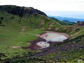 Baengnokdam in Hallasan
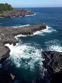
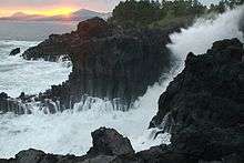 Waves crashing on Jeju seashore
 Halla Mountain in Jeju
Jejudo is a volcanic island, dominated by Hallasan: a volcano 1,950 metres (6,400 ft) high and the highest mountain in South Korea. The island measures approximately 73 kilometres (45 mi) across, east to west, and 41 kilometres (25 mi) from north to south.[14]
The island formed by volcanic eruptions approximately 2 million years ago, during the Cenozoic era.[15] The island consists chiefly of basalt and lava.
An area covering about 12% (224 square kilometres or 86 square miles) of Jejudo is known as Gotjawal Forest.[16] This area remained uncultivated until the 21st century, as its base of ʻAʻā lava made it difficult to develop for agriculture. Because this forest remained pristine for so long, it has a unique ecology.[17]
The forest is the main source of groundwater and thus the main water source for the half million people of the island, because rainwater penetrates directly into the aquifer through the cracks of the ʻAʻā lava under the forest. Gotjawal forest is considered an internationally important wetland under the Ramsar Convention by some researchers[18] because it is the habitat of unique species of plants and is the main source of water for the residents, although to date it has not been declared a Ramsar site.[19]
Formation
- About 2 million years ago, the island of Jeju was formed through volcanic activity.[15]
- About 1.2 million years ago, a magma chamber formed under the sea floor and began to erupt.
- About 700 thousand years ago, the island had been formed through volcanic activity. Volcanic activity then stopped for approximately 100 thousand years.
- About 300 thousand years ago, volcanic activity restarted along the coastline.
- About 100 thousand years ago, volcanic activity formed Halla Mountain.
- About 25 thousand years ago, lateral eruptions around Halla Mountain left multiple oreum (smaller 'parasitic' cones on the flanks of the primary cone).
- Volcanic activity stopped and prolonged weathering and erosion helped shape the island.[20]
Climate
Jeju has a humid subtropical climate, making it warmer than that of the rest of South Korea. Four distinct seasons are experienced on Jeju; winters are cool and dry while summers are hot, humid, and sometimes rainy.
In January 2016, a cold wave affected the region. Snow and frigid weather forced the cancellation of 1,200 flights on Jejudo, stranding approximately 90,300 passengers.[21]
| Climate data for Jeju City, Jejudo (1981–2010) | |||||||||||||
|---|---|---|---|---|---|---|---|---|---|---|---|---|---|
| Month | Jan | Feb | Mar | Apr | May | Jun | Jul | Aug | Sep | Oct | Nov | Dec | Year |
| Average high °C (°F) | 8.3 (46.9) |
9.4 (48.9) |
12.8 (55) |
17.5 (63.5) |
21.6 (70.9) |
24.8 (76.6) |
29.0 (84.2) |
29.8 (85.6) |
25.8 (78.4) |
21.3 (70.3) |
16.0 (60.8) |
11.0 (51.8) |
18.9 (66) |
| Daily mean °C (°F) | 5.7 (42.3) |
6.4 (43.5) |
9.4 (48.9) |
13.8 (56.8) |
17.8 (64) |
21.5 (70.7) |
25.8 (78.4) |
26.8 (80.2) |
23.0 (73.4) |
18.2 (64.8) |
12.8 (55) |
8.1 (46.6) |
15.8 (60.4) |
| Average low °C (°F) | 3.2 (37.8) |
3.6 (38.5) |
6.1 (43) |
10.2 (50.4) |
14.4 (57.9) |
18.7 (65.7) |
23.3 (73.9) |
24.3 (75.7) |
20.4 (68.7) |
15.1 (59.2) |
9.8 (49.6) |
5.3 (41.5) |
12.9 (55.2) |
| Average precipitation mm (inches) | 65.2 (2.567) |
62.6 (2.465) |
88.6 (3.488) |
89.6 (3.528) |
96.4 (3.795) |
181.4 (7.142) |
239.9 (9.445) |
262.5 (10.335) |
221.6 (8.724) |
80.3 (3.161) |
61.9 (2.437) |
47.7 (1.878) |
1,497.6 (58.961) |
| Average precipitation days (≥ 0.1 mm) | 12.6 | 10.3 | 11.2 | 10.0 | 10.4 | 11.8 | 12.5 | 13.5 | 10.8 | 7.0 | 9.3 | 10.8 | 130.2 |
| Average relative humidity (%) | 65.3 | 64.9 | 64.9 | 66.5 | 70.4 | 76.8 | 78.3 | 76.5 | 73.7 | 66.9 | 65.1 | 65.1 | 69.6 |
| Mean monthly sunshine hours | 70.4 | 105.4 | 158.9 | 194.4 | 211.9 | 170.9 | 195.6 | 195.6 | 161.7 | 178.5 | 126.0 | 84.8 | 1,854.1 |
| Source: Korea Meteorological Administration[22] | |||||||||||||
| Climate data for Seogwipo-si, Jejudo (1981–2010) | |||||||||||||
|---|---|---|---|---|---|---|---|---|---|---|---|---|---|
| Month | Jan | Feb | Mar | Apr | May | Jun | Jul | Aug | Sep | Oct | Nov | Dec | Year |
| Average high °C (°F) | 10.7 (51.3) |
11.6 (52.9) |
14.4 (57.9) |
18.5 (65.3) |
22.0 (71.6) |
24.6 (76.3) |
28.3 (82.9) |
30.1 (86.2) |
27.4 (81.3) |
23.4 (74.1) |
18.2 (64.8) |
13.2 (55.8) |
20.2 (68.4) |
| Daily mean °C (°F) | 6.8 (44.2) |
7.8 (46) |
10.6 (51.1) |
14.8 (58.6) |
18.6 (65.5) |
21.7 (71.1) |
25.6 (78.1) |
27.1 (80.8) |
23.9 (75) |
19.3 (66.7) |
14.1 (57.4) |
9.3 (48.7) |
16.6 (61.9) |
| Average low °C (°F) | 3.6 (38.5) |
4.4 (39.9) |
7.1 (44.8) |
11.3 (52.3) |
15.3 (59.5) |
19.2 (66.6) |
23.5 (74.3) |
24.6 (76.3) |
21.1 (70) |
15.9 (60.6) |
10.6 (51.1) |
5.9 (42.6) |
13.5 (56.3) |
| Average precipitation mm (inches) | 61.0 (2.402) |
77.1 (3.035) |
131.2 (5.165) |
174.9 (6.886) |
205.8 (8.102) |
276.9 (10.902) |
309.8 (12.197) |
291.6 (11.48) |
196.6 (7.74) |
81.6 (3.213) |
71.4 (2.811) |
45.1 (1.776) |
1,923 (75.709) |
| Average precipitation days (≥ 0.1 mm) | 10.3 | 9.5 | 11.0 | 10.5 | 10.7 | 12.9 | 14.3 | 14.2 | 10.3 | 6.1 | 7.4 | 8.1 | 125.3 |
| Average relative humidity (%) | 62.8 | 62.1 | 62.4 | 64.5 | 69.9 | 78.2 | 84.1 | 79.0 | 72.5 | 63.9 | 63.2 | 62.2 | 68.7 |
| Mean monthly sunshine hours | 152.2 | 152.6 | 174.0 | 190.9 | 199.0 | 144.2 | 142.1 | 184.2 | 176.1 | 207.1 | 170.5 | 161.8 | 2,054.7 |
| Source: Korea Meteorological Administration[23] | |||||||||||||
| Climate data for Seongsan-eup, Jejudo (1981–2010) | |||||||||||||
|---|---|---|---|---|---|---|---|---|---|---|---|---|---|
| Month | Jan | Feb | Mar | Apr | May | Jun | Jul | Aug | Sep | Oct | Nov | Dec | Year |
| Average high °C (°F) | 9.0 (48.2) |
10.2 (50.4) |
13.4 (56.1) |
17.8 (64) |
21.6 (70.9) |
24.2 (75.6) |
27.9 (82.2) |
29.5 (85.1) |
26.5 (79.7) |
22.0 (71.6) |
16.6 (61.9) |
11.4 (52.5) |
19.2 (66.6) |
| Daily mean °C (°F) | 5.4 (41.7) |
6.2 (43.2) |
9.3 (48.7) |
13.6 (56.5) |
17.5 (63.5) |
20.8 (69.4) |
24.9 (76.8) |
26.3 (79.3) |
23.1 (73.6) |
18.0 (64.4) |
12.5 (54.5) |
7.6 (45.7) |
15.4 (59.7) |
| Average low °C (°F) | 2.0 (35.6) |
2.4 (36.3) |
5.2 (41.4) |
9.2 (48.6) |
13.5 (56.3) |
17.6 (63.7) |
22.4 (72.3) |
23.6 (74.5) |
20.2 (68.4) |
14.2 (57.6) |
8.4 (47.1) |
3.9 (39) |
11.9 (53.4) |
| Average precipitation mm (inches) | 83.2 (3.276) |
69.7 (2.744) |
142.2 (5.598) |
150.1 (5.909) |
177.7 (6.996) |
223.7 (8.807) |
283.2 (11.15) |
360.6 (14.197) |
228.4 (8.992) |
90.8 (3.575) |
85.1 (3.35) |
72.0 (2.835) |
1,966.8 (77.433) |
| Average precipitation days (≥ 0.1 mm) | 11.1 | 9.1 | 10.9 | 9.1 | 9.4 | 12.4 | 13.0 | 13.6 | 9.8 | 5.8 | 7.7 | 8.9 | 120.8 |
| Average relative humidity (%) | 67.5 | 65.1 | 65.0 | 66.7 | 71.4 | 81.1 | 84.4 | 80.6 | 75.3 | 68.4 | 67.8 | 67.6 | 71.7 |
| Mean monthly sunshine hours | 122.5 | 146.9 | 170.1 | 192.9 | 205.3 | 145.6 | 157.4 | 173.4 | 157.2 | 187.8 | 155.5 | 130.3 | 1,944.7 |
| Source: Korea Meteorological Administration[24] | |||||||||||||
| Climate data for Gosan-ri, Jejudo (1981–2010) | |||||||||||||
|---|---|---|---|---|---|---|---|---|---|---|---|---|---|
| Month | Jan | Feb | Mar | Apr | May | Jun | Jul | Aug | Sep | Oct | Nov | Dec | Year |
| Average high °C (°F) | 8.6 (47.5) |
9.4 (48.9) |
12.3 (54.1) |
16.5 (61.7) |
20.0 (68) |
23.4 (74.1) |
27.3 (81.1) |
29.1 (84.4) |
26.0 (78.8) |
21.2 (70.2) |
16.2 (61.2) |
11.2 (52.2) |
18.4 (65.1) |
| Daily mean °C (°F) | 6.2 (43.2) |
6.7 (44.1) |
9.3 (48.7) |
13.3 (55.9) |
16.8 (62.2) |
20.6 (69.1) |
24.7 (76.5) |
26.2 (79.2) |
23.1 (73.6) |
18.3 (64.9) |
13.3 (55.9) |
8.6 (47.5) |
15.6 (60.1) |
| Average low °C (°F) | 3.8 (38.8) |
4.2 (39.6) |
6.5 (43.7) |
10.4 (50.7) |
14.2 (57.6) |
18.3 (64.9) |
22.7 (72.9) |
23.9 (75) |
20.6 (69.1) |
15.7 (60.3) |
10.7 (51.3) |
6.1 (43) |
13.1 (55.6) |
| Average precipitation mm (inches) | 43.9 (1.728) |
46.9 (1.846) |
75.8 (2.984) |
86.4 (3.402) |
110.2 (4.339) |
148.7 (5.854) |
178.0 (7.008) |
201.8 (7.945) |
116.2 (4.575) |
45.7 (1.799) |
57.4 (2.26) |
31.7 (1.248) |
1,142.8 (44.992) |
| Average precipitation days (≥ 0.1 mm) | 11.4 | 9.1 | 10.9 | 9.3 | 10.1 | 11.8 | 11.9 | 13.4 | 9.3 | 6.1 | 8.0 | 9.7 | 121 |
| Average relative humidity (%) | 67.0 | 68.4 | 69.5 | 73.2 | 79.5 | 85.1 | 88.4 | 83.2 | 77.2 | 69.0 | 67.1 | 66.0 | 74.5 |
| Mean monthly sunshine hours | 90.9 | 126.5 | 167.0 | 196.3 | 201.6 | 158.0 | 176.6 | 215.5 | 187.8 | 207.2 | 153.6 | 108.4 | 1,989.2 |
| Source: Korea Meteorological Administration[25] | |||||||||||||
| Climate data for Witse Oreum, Jejudo (2003–2009, elevation 1,672m) | |||||||||||||
|---|---|---|---|---|---|---|---|---|---|---|---|---|---|
| Month | Jan | Feb | Mar | Apr | May | Jun | Jul | Aug | Sep | Oct | Nov | Dec | Year |
| Average high °C (°F) | −1.6 (29.1) |
0.9 (33.6) |
3.4 (38.1) |
10.0 (50) |
14.9 (58.8) |
18.1 (64.6) |
20.3 (68.5) |
20.6 (69.1) |
18.1 (64.6) |
13.2 (55.8) |
6.8 (44.2) |
0.0 (32) |
10.4 (50.7) |
| Daily mean °C (°F) | −5.9 (21.4) |
−3.5 (25.7) |
−0.8 (30.6) |
5.2 (41.4) |
10.3 (50.5) |
14.0 (57.2) |
17.4 (63.3) |
17.4 (63.3) |
14.2 (57.6) |
8.2 (46.8) |
2.2 (36) |
−3.5 (25.7) |
6.4 (43.5) |
| Average low °C (°F) | −9.1 (15.6) |
−7.5 (18.5) |
−5.1 (22.8) |
0.7 (33.3) |
5.7 (42.3) |
10.4 (50.7) |
14.7 (58.5) |
14.5 (58.1) |
11.0 (51.8) |
4.3 (39.7) |
−0.9 (30.4) |
−6.6 (20.1) |
2.7 (36.9) |
| Average precipitation mm (inches) | 46.9 (1.846) |
128.0 (5.039) |
301.2 (11.858) |
426.1 (16.776) |
653.1 (25.713) |
651.9 (25.665) |
742.3 (29.224) |
836.4 (32.929) |
526.7 (20.736) |
126.5 (4.98) |
165.8 (6.528) |
64.6 (2.543) |
4,669.4 (183.835) |
| Source: Jeju Regional Meteorological Administration[26] | |||||||||||||
Economy
Tourism is an important component of the local economy. The island is sometimes called "South Korea’s Hawaii". Tourists from China do not require a visa to visit Jeju, unlike the rest of South Korea, and in the 2010s have started visiting on specialised package tours to acquire a South Korean driver's license; the test is similar to that in China, but can be completed in less time and is easier, application and test forms are available in many languages, and a South Korean license, unlike a Chinese license, makes the holder eligible for an International Drivers License.[27]
Education
- North London Collegiate School is an independent British boarding school in Seogwipo for boys and girls from 4 to 18.
Places of interest

- Manjanggul Lava Tube, 8 km long with a 1 km publicly accessible portion
- Seongsan Ilchulbong or "Sunrise Peak," a volcanic tuff cone and crater
- Mount Hallasan, the island's central dominant peak
- Seongeup Folk Village
- Jeju Teddy Bear Museum
- Jeju Loveland, a sex themed sculpture park
- O'Sulloc Tea Museum.
Utilities
The island's power-grid is connected to mainland plants by the HVDC Haenam–Cheju, and electricity is also provided by generators located on the island. As of 2001, there were four power plants on Jeju, with more under planning and construction. The most notable of these are the gas-fired generators of Jeju Thermal Power Plant, located in Jeju City. The present-day generators of this plant were constructed from 1982 onwards, replacing earlier structures that dated from 1968.[28] As elsewhere in Korea, the power supply is overseen by the Korea Electric Power Corporation, or KEPCO.
In February 2012, the governor of the state of Hawaii (USA), Neil Abercrombie, and the director of the Electricity Market and Smart Grid Division at the Korea Ministry of Knowledge Economy, Choi Kyu-Chong, signed a letter of intent to share information about Smart Grid technology. The Jeju Smart Grid was initially installed in 6,000 homes in Gujwa-eup and is being expanded. South Korea is using the pilot program of the Smart Grid on Jejudo as the testing ground in order to implement a nationwide Smart Grid by 2030.[29]
Transportation
The island is served by Jeju International Airport in Jeju City.[30] The Seoul – Jeju City air route is by a significant margin the world's busiest, with 10,156,000 passengers flown between the two cities in 2012.[31]Other cities that have flights to Jeju are Daegu, Busan, Gunsan and Gwangju.
Jeju is also accessible from Busan by ferry.[32] The travel time is between 3 and 12 hours.
On the island visitors can get around by the well connected public bus system[33] or by a rental car.
Cheju/Jeju Naval Base
In 1993 the Republic of Korea (ROK) began planning a naval base on Jejudo (Jeju) Island, and started construction in Gangjeong village in 2007, with planned completion by 2011. The base was designed to be a mixed military-commercial port similar to those in Sydney and Hawaii, that could accommodate 20 warships and 3 submarines, as well as 2 civilian cruise ships displacing up to 150,000 tons. Its official name is the Jeju Civilian-Military Complex Port. Jeju residents, environmentalists, and opposition parties opposed the construction, causing delays in the schedule. The base was completed in 2016.[34] Activists opposed to the plan[35] claim environmental hazards will damage the “Island of Peace” designated as such by the government.[36]
See also
- Alddreu Airfield
- Jeju black cattle, indigenous cattle breed
- Jeju horse, indigenous horse breed
- Jeju language
- Jeju Volcanic Island and Lava Tubes
References
- ↑ "Unesco names World Heritage sites". BBC News. June 28, 2007. Retrieved May 6, 2010.
- ↑ Hulbert, H. B (1905). "The Island of Quelpart". Bulletin of the American Geographical Society. 37 (7): 396. doi:10.2307/198722. JSTOR 198722.
- ↑ Hall, R. Burnett (1926). "Quelpart Island and Its People". Geographical Review. 16 (1): 60. doi:10.2307/208503. JSTOR 208503.
- ↑ "The Queen of Quelparte".
- ↑ Sokol, A. E (1948). "The Name of Quelpaert Island". Isis. 38 (3/4): 231–235. doi:10.1086/348077.
- ↑ "Jeju Island Facts".
- ↑ Hugh Deane (1999). The Korean War, 1945-1953. China Books&Periodicals, Inc. pp. 54–58. ISBN 9780141912240.
- 1 2 3 4 5 Merrill, John (1980). "Cheju-do Rebellion". The Journal of Korean Studies: 139–197.
- 1 2 3 Deane, Hugh (1999). The Korean War 1945-1953. San Francisco: China Books and Periodicals Inc. pp. 54–58. ISBN 978-0-8351-2644-1.
- 1 2 3 Kim, Hun Joon (2014). The Massacre at Mt. Halla: Sixty Years of Truth Seeking in South Korea. Cornell University Press. pp. 13–41. ISBN 9780801452390.
- ↑ Hideko takayama in tokyo (June 19, 2000). "Ghosts Of Cheju". newsweek. Retrieved 2009-03-30.
- ↑ O, John Kie-Chiang (1999). "Korean Politics: The Quest for Democratization and Economic Development". Cornell University Press.
- ↑ Song Jung Hee, Islanders still mourn April 3 massacre, Jeju Weekly, March 3, 2010
- ↑ Map of Korea: Cheju Island Archived 2016-03-04 at the Wayback Machine. The People's Korea. Accessed 8 July 2012
- 1 2 Woo, Kyung; Sohn, Young; Ahn, Ung; Spate, Andy (January 2013), "Geology of Jeju Island", Jeju Island Geopark - A Volcanic Wonder of Korea, Geoparks of the World (closed), 1: 13–14, doi:10.1007/978-3-642-20564-4_5, ISBN 978-3-642-20563-7
- ↑ "RISS 통합검색 - 국내학술지논문 상세보기". www.riss4u.net.
- ↑ "RISS 통합검색 - 학위논문 상세보기". www.riss4u.net.
- ↑ Jang, Yong-chang and Chanwon Lee, 2009, "Gotjawal Forest as an internationally important wetland," Journal of Korean Wetlands Studies, 2009, Vol 1.
- ↑ "Ramsar site list" (PDF). Archived from the original (PDF) on January 14, 2009. Retrieved 2007-06-20. Accessed June 2009
- ↑ "제주특별자치도 자연환경생태정보시스템". nature.jeju.go.kr. Archived from the original on 2016-07-12. Retrieved 2016-03-14.
- ↑ Ap, Tiffany (January 25, 2016). "Deaths, travel disruption as bitter cold grips Asia". CNN. Retrieved January 25, 2016.
- ↑ "평년값자료(1981–2010) 제주(184)". Korea Meteorological Administration. Retrieved 2011-05-23.
- ↑ "평년값자료(1981–2010) 서귀포(189)". Korea Meteorological Administration. Retrieved 2011-05-23.
- ↑ "평년값자료(1981–2010) 성산(188)". Korea Meteorological Administration. Retrieved 2011-05-23.
- ↑ "평년값자료(1981–2010) 고산(185)". Korea Meteorological Administration. Retrieved 2011-05-23.
- ↑ "제주도상세기후특성집(2010) 윗세오름(871)". Jeju Regional Meteorological Administration. Retrieved 2010-11-30.
- ↑ Craig, Erin (October 2, 2018). "The unusual reason Chinese tourists are going to S Korea". BBC News.
- ↑ "Jeju Thermal P/P". Korea Midland Power website. Archived from the original on June 16, 2005. Retrieved July 29, 2005.
- ↑ "Korea and Hawaii join forces in Smart Grid venture". The Jeju Weekly. Feb 24, 2012. Retrieved Mar 5, 2012.
- ↑ "Where To Stay In Jeju Island".
- ↑ "300 world 'super routes' attract 20% of all air travel, Amadeus reveals in new analysis of global trends". www.amadeus.com.
- ↑ "Ferry to Jeju".
- ↑ "The all new Jeju public transportation system".
- ↑ "Jeju naval base". The Korea Herald. 2016-02-29. Retrieved 2017-03-05.
- ↑ "Save Jeju Now". Retrieved 2017-03-05.
- ↑ "Cheju / Jeju Naval Base". GlobalSecurity.org. Retrieved 2017-03-05.
External links
