Jefferson Township, Clinton County, Ohio
| Jefferson Township, Clinton County, Ohio | |
|---|---|
| Township | |
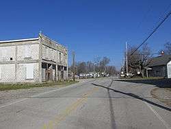 Buildings at Westboro | |
 Location of Jefferson Township in Clinton County | |
| Coordinates: 39°16′58″N 83°54′23″W / 39.28278°N 83.90639°WCoordinates: 39°16′58″N 83°54′23″W / 39.28278°N 83.90639°W | |
| Country | United States |
| State | Ohio |
| County | Clinton |
| Area | |
| • Total | 23.2 sq mi (60.1 km2) |
| • Land | 23.1 sq mi (59.9 km2) |
| • Water | 0.1 sq mi (0.3 km2) |
| Elevation[1] | 994 ft (303 m) |
| Population (2010) | |
| • Total | 1,399 |
| • Density | 61/sq mi (23.4/km2) |
| Time zone | UTC-5 (Eastern (EST)) |
| • Summer (DST) | UTC-4 (EDT) |
| FIPS code | 39-38542[2] |
| GNIS feature ID | 1085880[1] |
Jefferson Township is one of the thirteen townships of Clinton County, Ohio, United States. The 2010 census reported 1,399 people living in the township,[3] 1,084 of whom lived in the unincorporated portions of the township.
Geography
Located in the southwestern part of the county, it borders the following townships:
- Washington Township - north
- Clark Township - east
- Dodson Township, Highland County - southeast
- Perry Township, Brown County - southwest
- Marion Township - west
The entire township lies in the Virginia Military District.
The village of Midland is located in northwestern Jefferson Township.
Transportation
Major highways include U.S. Route 68 and State Routes 28 and 251.
Name and history
Named for President Thomas Jefferson, it is one of twenty-four Jefferson Townships statewide.[4]
It was erected from Clark and Marion townships by the Clinton County Commissioners in 1839.[5]
Government
The township is governed by a three-member board of trustees, who are elected in November of odd-numbered years to a four-year term beginning on the following January 1. Two are elected in the year after the presidential election and one is elected in the year before it. There is also an elected township fiscal officer,[6] who serves a four-year term beginning on April 1 of the year after the election, which is held in November of the year before the presidential election. Vacancies in the fiscal officership or on the board of trustees are filled by the remaining trustees.
References
- Clinton County Historical Society. Clinton County, Ohio, 1982. Wilmington, Ohio: The Society, 1982.
- Ohio Atlas & Gazetteer. 6th ed. Yarmouth, Maine: DeLorme, 2001. ISBN 0-89933-281-1
- Ohio. Secretary of State. The Ohio municipal and township roster, 2002-2003. Columbus, Ohio: The Secretary, 2003.
- 1 2 "US Board on Geographic Names". United States Geological Survey. 2007-10-25. Retrieved 2008-01-31.
- ↑ "American FactFinder". United States Census Bureau. Retrieved 2008-01-31.
- ↑ "Geographic Identifiers: 2010 Demographic Profile Data (G001): Jefferson township, Clinton County, Ohio". U.S. Census Bureau, American Factfinder. Retrieved January 22, 2015.
- ↑ "Detailed map of Ohio" (PDF). United States Census Bureau. 2000. Retrieved 2007-02-16.
- ↑ Brown, Albert J. (1915). History of Clinton County, Ohio: Its People, Industries, and Institutions. B.F. Bowen. p. 275.
- ↑ §503.24, §505.01, and §507.01 of the Ohio Revised Code. Accessed 4/30/2009.
External links
Municipalities and communities of Clinton County, Ohio, United States | ||
|---|---|---|
| City | 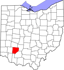 | |
| Villages | ||
| Townships | ||
| Unincorporated communities | ||
| Ghost town | ||
| Footnotes | ‡This populated place also has portions in an adjacent county or counties | |