Jardim Sulacap
| Jardim Sulacap | |
|---|---|
| Neighborhood | |
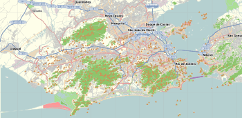 Jardim Sulacap Location in Rio de Janeiro  Jardim Sulacap Jardim Sulacap (Brazil) | |
| Coordinates: 22°53′30″S 43°23′44″W / 22.89167°S 43.39556°WCoordinates: 22°53′30″S 43°23′44″W / 22.89167°S 43.39556°W | |
| Country |
|
| State | Rio de Janeiro (RJ) |
| Municipality/City | Rio de Janeiro |
| Zone | West Zone |
| Area | |
| • Total | 786.92 ha (1,944.52 acres) |
| Population (2010) | |
| • Total | 13,062 |
| • Density | 1,700/km2 (4,300/sq mi) |
Jardim Sulacap is a neighborhood in the West Zone of Rio de Janeiro, Brazil.[1]
Jardim Sulacap is a middle-upper and middle class neighborhood in the West Zone of the city of Rio de Janeiro, Brazil. It limits with the districts Campo dos Afonsos, Vila Valqueire, Taquara, Magalhães Bastos and Realengo.
The Human Development Index in the year 2000 was 0.856, the 50th best in the city of Rio de Janeiro.
References
- ↑ "Bairro: Jardim Sulacap". Prefeitura da Cidade do Rio de Janeiro. Retrieved 4 October 2014.
This article is issued from
Wikipedia.
The text is licensed under Creative Commons - Attribution - Sharealike.
Additional terms may apply for the media files.